Sold2022Encyclo. Britannica C1880 Map. Paris City PlanLithograph Maps Published 1875-98, Edinburgh & London for "Encyclopaedia Britannica" Ninth Edition. Paper Size: 15.5 x 10.5 inch (39 x 27cm) Good ConditionSee Sold Price
Sold2017Plan of the City and Suburbs of New Orleans"Plan of the City and Suburbs of New Orleans; from An Actual Survey Made in 1815", by Jacques Tanesse, facsimile published Ithaca, New York: Historic Urban Plans, 1967, after the original published bySee Sold Price
Sold2023City plan of Paris. Jacobs, c.1850Paris France detailed city plan c.1850. Fine large engraved map by Jacobs. Published by Furne in Paris.; Numbered key identifies important buildings and locations. Inset lower left of the environs ofSee Sold Price
Sold2022PHILADELPHIA FOLIE (A.P.) To Thomas Mifflin Governor and Commander in Chief of the State of Penn...PHILADELPHIA FOLIE (A.P.) To Thomas Mifflin Governor and Commander in Chief of the State of Pennsylvania this Plan of the City and Suburbs of Philadelphia is Respectfully Inscribed by the Editor, 1794See Sold Price
Sold2023Map Of Philadelphia 1794 Thomas Mifflin GovernorMap Of Phila 1794, Thomas Mifflin Governor and Commander in Chief of the State of Pennsylvania. Plan for the City and Suburbs of Philadelphia. 1973 reproduction, #38 of 500, Historical Urban PlansSee Sold Price
Sold2019Desnos, Louis Charles 1765 Map of Paris, France"Pmiere. Flle. de l'Indicateur Fidele du Voyageur Francois" City Plan of Paris, showing routes out of the city to other parts of France. Copper Engraved Map Published 1765, Paris for "Coup d'oeil geneSee Sold Price
Sold2023PLAN OF THE CITY OF WASHINGTON Thackara & Valance Antique PrintLarge framed antique print of the original "Plan of the City of Washington" 1792 Thackara & Valance engraving.See Sold Price
Sold2020PARIS antique town city map plan. Building profiles.TITLE/CONTENT OF MAP: 'PARIS' DATE PRINTED: This map was originally published by Baldwin & Cradock in 1834; this date is printed on the map. This edition of the map was printed and published by ChapmaSee Sold Price
2018PARIS antique town city map plan. Omnibus routes.TITLE/CONTENT OF MAP: 'Letts's map of the City of Paris' DATE PRINTED: 1889 IMAGE SIZE: Approx 40.5 x 59.5cm, 16 x 23.5 inches (Large); Please note that this is a folding map. TYPE: Antique colour atlSee Sold Price
Sold2019Early European Map Views (10)Sebastian de Pontault, Knight of Beaulieu (1612? -1674). Plans and profiles of European cities. Engravings. Paris, late 17th Century. . 18 1/4" x 12".See Sold Price
Sold20191705 Engraved Plan City of Leige by De Fer1705 plan by Nicolas de Fer of the city of Liege, printed at Paris. Fine engraving . Measures 16 x 11”. Reserve: $20.00 Shipping: Domestic: Flat-rate of $5.00 to anywhere within the contiguous U.S.See Sold Price
Sold2024Large map engraving of Paris 1822 Auvray, Marchand d'Estampes , Quai MalaquaisAuvray, Marchand d'Estampes , Quai Malaquais N° 7, à Paris large engraving of the city of Paris .The plan divides the city into 12 arrondissements as opposed to the current 20. Scarce, finelSee Sold Price
Sold2024A scarce and very large plan of Montreal[MAP-CANADA] ADAMS, JOHN, surveyor. Map of the City and Suburbs of Montreal ... Constructed from a New Survey, 1825 by John Adams. New York: Engraved by J. D. Stout, 1825. Engraved map on three largeSee Sold Price
Sold2022New road map of the city of Paris 1839 Rosselin editeur engravingNouveau plan routier de la ville de Paris, Guide exacte de cette capitale : en 12 arrondissemens avec leurs mairies et en 48 quartiers, 1839V. ROSSELIN (19th century), print editor, Paris, EstablishedSee Sold Price
Sold2020Georges Louis Rouge Plan of Paris Map 1765Georges-Louis Le Rouge (ca. 1712-1780), "Plan de Paris et de ses faubourgs en l'état qu'il étoit en 1765." This attractive map features the city of Paris along with points of interest. DimensionSee Sold Price
Sold20221722 Paris FRANCE Architecture Illustrated Notre Dame1722 Paris FRANCE Architecture Illustrated Notre Dame MAPS City Plans Force 2v A rare geographical study of France by Piganiol! Piganiol de la Force was an 18th-century French author known almost exclSee Sold Price
Sold2019Prevost: Three City Plans, Hubei/Hunan Provinces, ChinaMap Title: Plans de quelques Villes de la Province de Hou-Quang— Yong Tcheou Fou; Vou-Tchang-Fou; Hoang-Tcheou-Fou Cartographer: Bellin/van der Schley/Prevost d'Exile Place/Date: Paris/The Hague / 1See Sold Price
Sold2018Map of the City of Somerville. 1896.Title: Map of the City of Somerville. 1896. Date: 1896 Cartographer: BAILEY, ERNEST W. Size: 17.6 X 29.5 Street plan of a city on the Mystic River between Cambridge and Medford, suburbs of Boston. GeoSee Sold Price
Sold2023Map, City Of Athens, Circa 1890Map of the city of Athens (Plan d'Athenes) printed by Lemercier & Cie, Paris, circa 1890. 15 3/8 x 15 inches. Repairs to some of the folds.Lot Note: Map removed from Guides Joanne, a French travel guiSee Sold Price
Sold2022AN ANTIQUE PRINTED MAP BY J. N. BELLIN, Paris 1752. PLAN DE LA VILLE DE MEACO. CopperplateAN ANTIQUE PRINTED MAP BY J. N. BELLIN, Paris 1752. PLAN DE LA VILLE DE MEACO. Copperplate Uncoloured. A well engraved and detailed plan of the port and city of Meaco, present-day Kyoto. Jacques NicolSee Sold Price
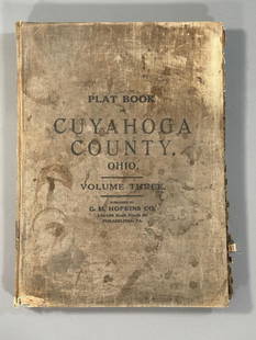
Sold2023Plat Book of the City of Cleveland, Ohio, Volume Three 1914Philadelphia: G.M. Hopkins, 1914. This atlas was issued as Volume 3 of the title Plat-book of the city of Cleveland, Ohio and suburbs, complete in two volumes from official records, private plans andSee Sold Price
Sold2022Nicolas de La Mare (French, 1639–1723), Antoine Coquart (French, 1668–1707), and Nicolas de FerNicolas de La Mare (French, 1639–1723), Antoine Coquart (French, 1668–1707), and Nicolas de Fer (French, 1646-1720), "Cinquieme Plan de la Ville de Paris," c. 1705, hand-colored map, preSee Sold Price
Sold2016"Plan de la Nouvelle Orleans," by Jacques Nicolas"Plan de la Nouvelle Orleans," by Jacques Nicolas Bellin, Paris, 1764, hand colored copper engraving, depicting the French Quarter, with a list of keys across the top and turbulent waves of the MissisSee Sold Price
Sold2019Alexandre Vuillemin (1812-1880), "Neuer Plan vonAlexandre Vuillemin (1812-1880), "Neuer Plan von Paris," 1837, hand colored, H.- 16 3/8 in., W.- 21 3/8 in.See Sold Price
2 days LeftCollective HudsonHunt Slonem, Hand Signed Oil On Panel Wall Hanging Sculpture, 1999 "Toco"$4,000
6 days LeftJasper52FRENCH SUDAN (Now Mali). Soudan Français. Bamako city plan de la ville 1938 map$25
6 days LeftJasper52FRENCH SUDAN (Now Mali). Soudan Français. Bamako city plan de la ville 1929 map$25
6 days LeftJasper52FRENCH SUDAN (Now Mali). Soudan Français. Bamako city plan de la ville 1931 map$25
5 days LeftMynt AuctionsSaint Laurent SAINT LAURENT PARIS City Backpack Mini 508548 99HIE 1077 Rucksack/Backpack Star$10
Jun 13TheRedFinch AuctionsParis 1937, 31 etchings in full page by Matisse, Vlaminck, Derain, Van Dongen, Bonnard, and others.$2,000
5 days LeftJasper521950's French Village in Winter River Landscape Signed Impressionist Oil c. 1950's$200
2 days LeftCollective HudsonMarcel Vertes Signed Crayon Painting of a Stylish Young Parisian$300(1 bid)
Jun 30Global Auctions CompanyRoderic (O'Connor) Montagu (1907 - 2001) Oil painting Female Acrobat figure$200
Jun 30Global Auctions CompanyRoderic (O'Connor) Montagu (1907 - 2001) Oil painting Harlequin Acrobat figure$200
BonhamsBLAEU (JAN) Delfi Batavorum vernacule Delft, [Amsterdam, 1649 or later]; BLAEU (WILLEM) Novus X...£10


![A scarce and very large plan of Montreal: [MAP-CANADA] ADAMS, JOHN, surveyor. Map of the City and Suburbs of Montreal ... Constructed from a New Survey, 1825 by John Adams. New York: Engraved by J. D. Stout, 1825. Engraved map on three large](https://p1.liveauctioneers.com/292/326828/175962870_1_x.jpg?height=310&quality=70&version=1713473479)


![BLAEU (JAN) Delfi Batavorum vernacule Delft, [Amsterdam, 1649 or later]; BLAEU (WILLEM) Novus X... (1 of 9)](https://p1.liveauctioneers.com/1043/319451/178359083_1_x.jpg?height=282&quality=70&version=1716978850)