Sold2022(INDIA.) James Rennell, surveyor. A Map of the North Part of Hindoostan(INDIA.) James Rennell, surveyor. A Map of the North Part of Hindoostan or a Geographical Survey of the Provinces of Bengal, Bahar, Awd, Ellahabad, Agra and Dehli. Large engraved map of northern IndiaSee Sold Price
Sold2018Bengal With Its Divisions, and the Adjacent CountriesTitle/Content of Map: Bengal With Its Divisions, and the Adjacent Countries Date: 1778 Cartographer: [RENNELL, JAMES/J. CHEEVERS] Size: 14.3X20.5 Please note that this lot has a confidential reserve.See Sold Price
Sold20241831 SDUK Map of Bengal / Bangladesh -- India Bengal PresidencyTitle: 1831 SDUK Map of Bengal / Bangladesh -- India Bengal Presidency Cartographer: SDUK Year / Place: 1831, London Map Dimension (in.): 14 X 10.2 in. This is a very nice map of the Ganges and BrahmaSee Sold Price
Sold20231831 SDUK Map of Bengal / Bangladesh -- India Bengal PresidencyTitle: 1831 SDUK Map of Bengal / Bangladesh -- India Bengal Presidency Cartographer: SDUK Year / Place: 1831, London Map Dimension (in.): 14 X 10.2 in. This is a very nice map of the Ganges and BrahmaSee Sold Price
Sold2019Bryce, James 1881 Map of Bengal, IndiaLithograph Map Published 1881, London for ""The International Atlas and Geography..." by James Bryce. Maps by Edward Weller & John Bartholomew. Uncommon. Paper Size: 18 x 13 inch (46 x 33cm) Good CondSee Sold Price
Sold2018Bryce, James 1881 Map of Lower Bengal, IndiaLithograph Map Published 1881, London for ""The International Atlas and Geography..." by James Bryce. Maps by Edward Weller & John Bartholomew. Uncommon. Paper Size: 18 x 13 inch (46 x 33cm) Good CondSee Sold Price
Sold20211752 Map of Indoustan India Bengal KashmirA map of Jacques Bellin showing a portion of India, "Carte de L'Indoustan", printed at Paris circa 1752, shows portion including Kashmir and Bengal. Fine folding, measures 15 x 10". Reserve: $100.00 SSee Sold Price
Sold2017Bellin: Antique Map of Kingdom of Bengal, 1760Map: Nouvelle Carte du Royaume de Bengale Cartographer: Bellin Place & Date: Paris / 1760 Size: 13 3/8" x 11" Condition: b&w with color highlights; a strong, dark impression The scarce, beautifully enSee Sold Price
Sold2022(INDIA.) James Rennell, surveyor. A New Map of Hindoostan.(INDIA.) James Rennell, surveyor. A New Map of Hindoostan. Large engraved map of the Indian subcontinent and Sri Lanka. 4 sheets joined as two, approximately 24½x57½ inches each section; oriSee Sold Price
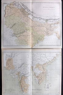
Sold2021Nolan, Edward C1880 Pair of Maps of India"India. The Bombay Presidency/India. The Madras Presidency" and "India The Bengal Presidency" Steel Engraved Map Published C1880, London for "The Illustrated History of the British Empire in India andSee Sold Price
Sold2018Weller: Antique Map of British India, 1863TITLE/CONTENT OF MAP: 'India the North West Provinces and Oude' Dehli. Nepal. DATE PRINTED: 1863 IMAGE SIZE: Approx 31.5 x 44.5cm, 12.5 x 17.5 inches (Large) TYPE: Antique map with original outline coSee Sold Price
Sold2019BRITISH INDIA. 'The North West Provinces & Oude'.TITLE/CONTENT OF MAP: 'India the North West Provinces and Oude' DATE PRINTED: 1863 IMAGE SIZE: Approx 31.5 x 44.5cm, 12.5 x 17.5 inches (Large) TYPE: Antique map with original outline colour CONDITIONSee Sold Price
Sold2020India.- Royal Bengal Engineers.- Sketch Plan of theIndia.- Royal Bengal Engineers.- Sketch Plan of the City of Lucknow, large manuscript map of the capital of the state of Uttar Pradesh, pen and inks, watercolour wash, traces of pencil, on wove paper,See Sold Price
Sold2023Near Gangwaugh Colly on the River Hoogly, Mausoleum of Sultan Chusero near Allahabad, Hindoo TemplesNear Gangwaugh Colly on the River Hoogly, Mausoleum of Sultan Chusero near Allahabad, Hindoo Temples at Agouree of River Bahar, The Sacred Tree at Gyah in Bahar, colored engravings on paper Drawn andSee Sold Price
Sold20181775 BENGAL East India Trading Co South ASIA Hindu Brit1775 BENGAL East India Trading Co South ASIA Hindu British MAP William Bolts William Bolts was an 18th-century Dutch merchant who worked predominantly for the British East India Company; however, he gSee Sold Price
Sold20211729 HISTORY of JEWS w/ MAPS of GREECE PALESTINE ASIAPRIDEAUX, H. Het oude & niewe verbond aen een geschakelt in de geschiedenissen der Joden en der aengrenzende volkeren, sedert het verval der koningryken van Israel en Juda tot de komst van Jezus KristSee Sold Price
Sold2022John Smith Map of New England, Extremely Rare 2nd StateSMITH, John (1580-1631). New England the most remarqueable parts thus named by the high and mighty Prince Charles, Prince of great Britaine. Observed and described by Captayn John Smith... CopperplateSee Sold Price
Sold2022Pierre Jan van der Ouderaa (Belgian, 1841-1915) Foor in de Oude Buers te AntwerpenPierre Jan van der Ouderaa (Belgian, 1841-1915) Foor in de Oude Buers te Antwerpen signed and dated 'P.VANDER OUDERAA/Antwerpen 1892' (lower right) oil on canvas 138 x 203.5cm (54 5/16 x 80 1/8in).See Sold Price
2021GREAT NORTHERN’S 2 GREAT TRAINS SYSTEM MAP.Huge dramatic reverse glass advertising Great Northern's two great trains, Empire Builder and Western Star. In script just below Great Northern logo it states "Steamliners twice a day, each way, betweSee Sold Price
Sold2022[STREETER COPY] SEARCY, I. G. Map of Florida constructed principally from authentic documents in the[STREETER COPY] SEARCY, I. G. Map of Florida constructed principally from authentic documents in the Land office at Tallahassee by I. G. Percy. Published by I.G. Searcy Tallahassee & F. Lucas Jr., BalSee Sold Price
Sold2020Gastaldi Map of Africa*** START PRICE IS THE RESERVE *** [Africa]. GASTALDI, Giacomo (1500-1566) & FORLANI, Paolo (fl. 1560-1571). La Descrittione dell'Africa. Engraved Map. Venice: Paolo Forlani, 1562. 19 x 25 1/4 inchesSee Sold Price
Sold2016T-O World Map.- Lucanus (Marcus Annaeus) Pharsalia,Lucanus (Marcus Annaeus) Pharsalia, manuscript on paper, [Northern Italy (possibly Padua), first half of the fifteenth century]. 294 x 217mm., I + 149 + I leaves (including defective leaves and 3 blanSee Sold Price
Sold2024Petrus Plancius, Engraved World MapOrbis Terrarum Typus de Integro Multis in Locis Emendatus. Petrus Plancius (1552-1622). Copper-plate engraving with original hand color in full. Amsterdam, 1594. Some stains, creases, folds. Sight sizSee Sold Price
Sold2015A Fine & Rare Map of New York.Bernard Ratzer "Plan of the City of New York". Signed lower right in the plate "T. Kitchin Sculpt" (Kitchin recorded the cartographer's name as Ratzen (sic) rather than Ratzer). The map backed, rolledSee Sold Price
23 hrs LeftJasper52The gibeonites deceive Joshua - Dutch Bible Scenes - Antique Engraving (c.1720)$65
7 days LeftJasper521899. Entrance to the zuyder zee, after Clarkson Stanfield - Antique illustration$35
19 hrs LeftCedarburg Auction & Appraisals LLCSet of Four Maps Showing All of Spain and Portugal c. 1700's$450(2 bids)
19 hrs LeftCedarburg Auction & Appraisals LLCRare 1877 Double sided map of Milwaukee and Wisconsin$125(7 bids)
Jun 07Freeman's | Hindman[MAP]. TODESCHI, Pietro. [Nova et Acurata Totius Americae Tabula auct. G.I. Blaeu] America quarta$5,000
Jun 08Early American History Auctions1720 Colonial Northumberland County Virginia Manuscript Deed and Map Plot$400
Jun 07Freeman's | Hindman[MAP]. ORTELIUS, Abraham. Americae Sive Novi Orbis, Nova Descriptio. 1573.$1,000(1 bid)
2 days LeftAntiques Online AuctionsVintage Texas 1845 Map Printed in 1986, Compiled by John Davis$60(4 bids)


![Bengal With Its Divisions, and the Adjacent Countries: Title/Content of Map: Bengal With Its Divisions, and the Adjacent Countries Date: 1778 Cartographer: [RENNELL, JAMES/J. CHEEVERS] Size: 14.3X20.5 Please note that this lot has a confidential reserve.](https://p1.liveauctioneers.com/5584/121250/61718392_1_x.jpg?height=310&quality=70&version=1525220936)


![[STREETER COPY] SEARCY, I. G. Map of Florida constructed principally from authentic documents in the: [STREETER COPY] SEARCY, I. G. Map of Florida constructed principally from authentic documents in the Land office at Tallahassee by I. G. Percy. Published by I.G. Searcy Tallahassee & F. Lucas Jr., Bal](https://p1.liveauctioneers.com/292/250642/130213737_1_x.jpg?height=310&quality=70&version=1654271664)
![Gastaldi Map of Africa: *** START PRICE IS THE RESERVE *** [Africa]. GASTALDI, Giacomo (1500-1566) & FORLANI, Paolo (fl. 1560-1571). La Descrittione dell'Africa. Engraved Map. Venice: Paolo Forlani, 1562. 19 x 25 1/4 inches](https://p1.liveauctioneers.com/1968/163248/82424552_1_x.jpg?height=310&quality=70&version=1583340284)
![T-O World Map.- Lucanus (Marcus Annaeus) Pharsalia,: Lucanus (Marcus Annaeus) Pharsalia, manuscript on paper, [Northern Italy (possibly Padua), first half of the fifteenth century]. 294 x 217mm., I + 149 + I leaves (including defective leaves and 3 blan](https://p1.liveauctioneers.com/5458/94966/48431616_1_x.jpg?height=310&quality=70&version=1476369049)


![[India] Rennell, James, Major (1 of 2)](https://p1.liveauctioneers.com/94/330664/178342480_1_x.jpg?height=282&quality=70&version=1716466933)


![[MAP]. TODESCHI, Pietro. [Nova et Acurata Totius Americae Tabula auct. G.I. Blaeu] America quarta (1 of 1)](https://p1.liveauctioneers.com/197/329395/177650542_1_x.jpg?height=282&quality=70&version=1715364962)


![[MAP]. ORTELIUS, Abraham. Americae Sive Novi Orbis, Nova Descriptio. 1573. (1 of 2)](https://p1.liveauctioneers.com/197/329395/177650534_1_x.jpg?height=282&quality=70&version=1715364962)

