Sold20223 books of the world, incl. a map of the RhineLot of 3 books: 1. NEUES PANORAMA DES RHEINS VON MAINZ BIS CoLN. Frankfurt am Main: Friedrich Wilhelm Delkeskamp's Verlage, n.d. [c. 1850s]. Blue paper with pictorial decorative printing on boards (7See Sold Price
Sold2019Guillaume De L’isle (1675-1726), "The Seat of War onGuillaume De L’isle (1675-1726), "The Seat of War on the Rhine a new Map of the Course of the River from Basil to Bonn," 1710, H. - 53 in., W. - 25 in.See Sold Price
Sold20223 Maps From WW1St. Mihiel Offensive and Meuse Argonne Offensive, Invasion Map of Europe, and a Panorama Map of the Rhine for American Army of Occupation fromn the Y.M.C.A. 1919.See Sold Price
Sold2022Lot of 3 Various Maps of New York CityLot of 3 various maps of New York City, all show various stages of wear, yellowing, slight age staining & some ripping (mostly at the folds): Panorama of the New York Zoological Park, The Supervue MapSee Sold Price
Sold20191919 Rhine River Birds Eye View for Occupying US ForcesTitle/Content of Map: 1919 Rhine River Birds Eye View for Occupying US Forces -- Rhine Panorama for the Men of the American Army of OccupationÂ… Date: 1919 Cartographer: YMCA sponsored Size: 62.6 XSee Sold Price
Sold2022(RHINE RIVER.) Friedrich Wilhelm Delkeskamp, after. Panorama des Rheins und Seiner Nächsten(RHINE RIVER.) Friedrich Wilhelm Delkeskamp, after. Panorama des Rheins und Seiner Nächsten Umgebungen von Mainz bis Cöln. Folding etched panorama of the Rhine River between the German townsSee Sold Price
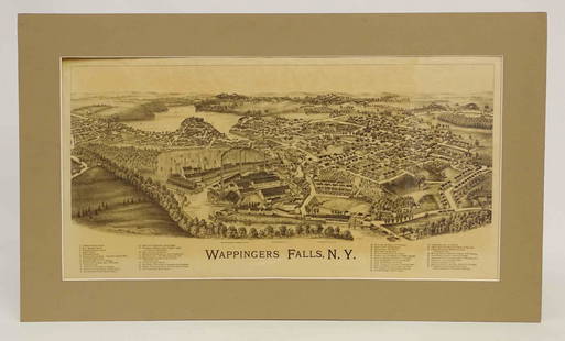
Sold2022Wappingers Falls New York Large ViewWappingers Falls, N.Y. Large Panorama Bird's-eye Map. L.R. Burleigh, Troy, New York, c. 1889. Antique print. 15" x 29".See Sold Price
Sold2019Magnus Birds' Eye View of San Francisco -- Panorama ofReserve Reduced! Map Title/Content: Magnus Birds' Eye View of San Francisco -- Panorama of San Francisco Cartographer: C Magnus Year / Place: 1860, New York Map Dimension (in.): 4 X 7.9 in This is a bSee Sold Price
Sold2023CHINA JEFFERSON (LOUISE E.) China. A Friendship Map, New York, Friendship Press, Inc., 1948CHINA JEFFERSON (LOUISE E.) China. A Friendship Map, pictorial colour printed map, numerous illustrations of famous sites, industries, and views, six portraits (including Sun Yat-sen, Chiang Kai-shekSee Sold Price
Sold201510 Maps: New York street grid, views, US, MD[New York/Maryland/US] 10 Maps. 8 1/8 x 9 3/4 in. to 17 7/8 x 27 1/2 in. Sold with all faults. ++ MAP OF THE CITY OF NEW-YORK 1852. Folding map from an annual edition of Valentine’s Manual. ++ PARTSee Sold Price
Sold2022J.H. COLTON (1800-1893) A MAP, "New Map of the State ofJ.H. COLTON (1800-1893) A MAP, "New Map of the State of Texas," NEW YORK, CIRCA 1855, hand-colored lithograph on paper, "Compiled from J. de Cordova's large Map," and, "Published by J.H. Colton & Co.,See Sold Price
Sold2019Large map, New York City's UWS, 1879Large map, New York City's UWS, 1879, "West End Plateau of New York" by Herman K. Viele, City Surveyor, printed by Johnson & Pratt, New York, 1879, framed under acrylic, with 25-page booklet in pocketSee Sold Price
Sold20241746 Large Engraved Map New England Nova ScotiaA New Chart of the Coast of New England, Nova Scotia, New France or Canada with the Islands of NewFoundl(an)d, Cape Breton, St. John and C.. by Nicolas Bellin, English version printed for Gentleman'sSee Sold Price
Sold2017Antique Map: New York & Area - EngravingPensylvania Nova Jersey et Nova York cum Regionibus Ad Fluvium Delaware In America Sitis, Nova Delinatione ob oculos posita...Tobias Conrad Lotter (1717 - 1777). Engraved map with hand-color in part.See Sold Price
Sold2020AN ANTIQUE MAP, "New Railroad Map of the United States,AN ANTIQUE MAP, "New Railroad Map of the United States, the Dominion of Canada, Mexico and the West Indies," CHICAGO, CIRCA 1875, hand-colored lithograph on paper, publishing, engraving, and printingSee Sold Price
Sold20171746 Leather Volume Map New England English Rebellion1746 Volume , featuring large folding “New Chart of the Coast of New England Nova Scotia, New France or Canada…”, of Gentleman’s Magazine for the year 1746 containing all twelve issues and SupSee Sold Price
Sold2019POMPEII antique town city map & panorama. Domus Pansae;TITLE/CONTENT OF MAP: 'POMPEII.; inset Domus Pansae; plan of the coast in the vicinity of Vesuvius' DATE PRINTED: This map was originally published by Baldwin & Cradock in 1832; this date is printed oSee Sold Price
Sold2021Tallis, John (Pub) 1852 Map. New ZealandSteel Engraved Map with Original Outline Hand Color Published 1852-56 by John Tallis, London for "The Universal Pronouncing Dictionary" by Thomas Wright. Drawn & Engraved by John Rapkin. Centre fold aSee Sold Price
Sold2016[Map] New Map North America 1855Jacob Monk ,Baltimore; North America and Territories, Canada,Central America and West Indies, 57 x 62 in. Large Roll down map.See Sold Price
Sold2023Rand McNally Auto Road Map New Jerseyrated 9, 7.5"x4.5", has good colorSee Sold Price
Sold2020Rare Map New Guinea latest discoveries by DampierTitle: Rare Map New Guinea latest discoveries by Dampier Date/Period: 1744-1748. Materials: Copperplate engraved Dimensions: 16x9 3/4”. Subject. Map of discoveries by Dampier. New Guinea. SurroundSee Sold Price
Sold2021POMPEII Antique city town map panorama Domus Pansae BayTITLE/CONTENT OF MAP: 'POMPEII.; inset Domus Pansae; plan of the coast in the vicinity of Vesuvius' The top image on the right hand side shows the entire map. To view a close up of the map showing theSee Sold Price
Sold2023M. Dripps 1860 Map New York City County & Vacinity By M. DrippsM. Dripps 1860 Map New York City County & Vacinity By M. Dripps 22.5" x 30"See Sold Price
Sold2023MAP: NEW MAP OF ARKANSAS, STEAMBOAT ROUTES, 1854Framed map, "A New Map of Arkansas, with its Canals Roads & Distances," c.1854, published by Thomas, Cowperthwait & Company, No. 253 Market Street, Philadelphia, hand colored, includes steamboat routeSee Sold Price
6 days LeftHermann Historica GmbHFriedrich Herchenhein, New Panorama of the Rhine from Mannheim to Cologne, steel engraving, Mainz,€300
May 17Albion AuctionsPaterson & Mogg C1830 British Road Map. New Shorehamd to Chichester to Fareham$5(1 bid)
May 17Albion AuctionsStieler, Adolf 1909 Antique Map. New Zealand - South Sea Islands, Pacific Australia Hawaii$5
May 16Potter & Potter Auctions[NEW YORK CITY – PICTORIAL MAPS]. Group of 3 pictorial maps...$200(1 bid)
May 22Thomaston Place Auction GalleriesCOLLECTION OF TRAVEL EPHEMERA, BROCHURES, BOOKLETS, MAPS 1900-1950$100
10 hrs LeftJasper52General Map of the West Indies'. West sheet only. Bryan EDWARDS. Caribbean 1794$700
6 days LeftAkiba Galleries(2 Pc) Allain Manesson Mallet Description De L'Univers 2 Vol. German Translation$200(1 bid)


![3 books of the world, incl. a map of the Rhine: Lot of 3 books: 1. NEUES PANORAMA DES RHEINS VON MAINZ BIS CoLN. Frankfurt am Main: Friedrich Wilhelm Delkeskamp's Verlage, n.d. [c. 1850s]. Blue paper with pictorial decorative printing on boards (7](https://p1.liveauctioneers.com/4473/230685/119376122_1_x.jpg?height=310&quality=70&version=1639920690)


![10 Maps: New York street grid, views, US, MD: [New York/Maryland/US] 10 Maps. 8 1/8 x 9 3/4 in. to 17 7/8 x 27 1/2 in. Sold with all faults. ++ MAP OF THE CITY OF NEW-YORK 1852. Folding map from an annual edition of Valentine’s Manual. ++ PART](https://p1.liveauctioneers.com/179/82189/42599761_1_x.jpg?height=310&quality=70&version=1447864785)


![[Map] New Map North America 1855: Jacob Monk ,Baltimore; North America and Territories, Canada,Central America and West Indies, 57 x 62 in. Large Roll down map.](https://p1.liveauctioneers.com/523/85328/43939935_1_x.jpg?height=310&quality=70&version=1455914464)


![[NEW YORK CITY – PICTORIAL MAPS]. Group of 3 pictorial maps... (1 of 3)](https://p1.liveauctioneers.com/928/325952/175495562_1_x.jpg?height=282&quality=70&version=1712935174)


