Sold2024West Indies with the Harbour & Fort of Omoa from the best… JOHN LODGE 1780 mapTITLE/CONTENT OF MAP: 'West Indies, with the Harbour & Fort of Omoa. From the Best Authorities' DATE PRINTED: March 1780 IMAGE SIZE: Approx 31.5 x 66.5cm, 12.25 x 26 inches (Large); Please note that tSee Sold Price
Sold2022A Plan of Charles Town the Capital of South Carolina… Charleston. LODGE 1780 mapTITLE/CONTENT OF MAP: 'A Plan of Charles Town the Capital of South Carolina, with the Harbour, Islands and Forts; the Attack on Fort Sulivan, by His Majesty's Ships under Sir Peter Parker, in 1776; thSee Sold Price
Sold2023MEXICO CENTRAL AMERICA WEST INDIES. Panama & Proposed Nicaragua canals 1912 mapMexico, Central America & West Indies; Inset maps of Leeward & Windward Islands; Mexico; Matina Bay; Jamaica; Havana; Panama Canal;' by John Bartholomew & Co., Edin. (1912). Antique colour atlas map;See Sold Price
Sold2018Map of Narragansett Rhode IslandReproduced in Collotype from the original in the John Carter Brown Library (Reduced one quarter) 1956. A topographical chart of the bay of Narraganset in the province of New England, with all the isleSee Sold Price
Sold2019Bahama Islands, Harbours and Anchorages, BritishTitle/Content of Map: Bahama Islands, Harbours and Anchorages, British Admiralty Chart 409, published 1897 Date Printed: Surveyed in 1830 – 1835 Published: 1897 Edition: 1rst publication CartograpSee Sold Price
Sold2019John Cobb Narragansett Bay Rhode Island MapMassachusetts,20th Century Aerial view map with scenic landscape decoration of Narragansett Bay. Frame 19" x 22 1/2", From the collection of a North Scituate, Rhode Island gentleman.See Sold Price
Sold2021Map of Jamaica, 1839Map of Jamaica, 1839A nicely colored map of the island nation of Jamaica, “compiled chiefly fro manuscripts in the colonial office and admiralty by John Arrowsmith”. This map shows high deSee Sold Price
Sold2019John Senex (1678-1740), "A New Map of the EnglishJohn Senex (1678-1740), "A New Map of the English Empire in the Ocean of America or West Indies, A New Map of the Island of Jamaica," c. 1798, hand colored, H.- 22 in., W.- 26 1/4 in.See Sold Price
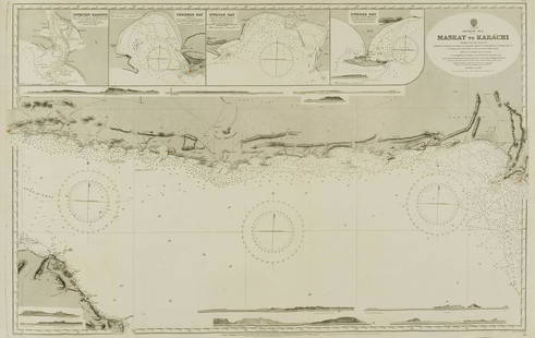
Sold2022Middle East.- Oman.- Admirality Hydrographic Office (The) Maskat to Karachi, engraved chart, 1916.Middle East.- Oman.- Admirality Hydrographic Office (The) Maskat to Karachi, showing the coast from Maskat to Karachi, the Gulf of Oman, with inset maps of Sonmoyani Harbour, Chahbar Bay, Gwatar Bay aSee Sold Price
Sold2018NORTH SEA coast chart. East Anglia Holland Flanders.TITLE/CONTENT OF MAP: 'A correct chart of the sea coasts of England, Flanders and Holland. Shewing the sands, shoals, rocks and dangers, the bays, harbours, roads, buoys, beacons & seamarks on the saiSee Sold Price
Sold2023POLYNESIA/PACIFIC ISLANDS. inc Sandwich/Hawaiian islands. RAPKIN/TALLIS 1851 mapCAPTION PRINTED BELOW PICTURE: 'Polynesia or Islands in the Pacific Ocean' Vignettes: Resolution Bay, Marquesas; Harbour of Dory, New Guinea; Otaheite [Tahiti]; Kalakakooa, Sandwich Islands [HawaiianSee Sold Price
Sold2018POLYNESIA/PACIFIC ISLANDS. inc Sandwich/HawaiianTITLE/CONTENT OF MAP: 'Polynesia or Islands in the Pacific Ocean' Vignettes: Resolution Bay, Marquesas; Harbour of Dory, New Guinea; Otaheite [Tahiti]; Kalakakooa, Sandwich Islands [Hawaiian islands].See Sold Price
2018POLYNESIA/PACIFIC ISLANDS. inc Sandwich/HawaiianReserve Reduced! TITLE/CONTENT OF MAP: 'Polynesia or Islands in the Pacific Ocean' Vignettes: Resolution Bay, Marquesas; Harbour of Dory, New Guinea; Otaheite [Tahiti]; Kalakakooa, Sandwich Islands [HSee Sold Price
Sold2022Chart of the Mediterranean Sea. Marseilles Genoa Gibraltar. THOMSON 1830 mapTITLE/CONTENT OF MAP: 'Chart of the Mediterranean Sea // Bay & roads of Marseilles // The harbour of Genoa // Plan of the Rock and Bay of Gibraltar, shewing the position of the combined fleet and attaSee Sold Price
Sold2017Thomson: Antique Chart Map of Mediterranean Sea, 1817Chart of the Mediterranean Sea. Bay & roads of Marseilles. The harbour of Genoa. Plan of the Rock and Bay of Gibraltar, shewing the position of the combined fleet and attack of the battering ships inSee Sold Price
Sold2022Large lot of 1960s Nautical Chart Maps Martha's Vineyard, Block Island, LI Sound Cape Cod Bay & moreLarge lot of 1960s Nautical Chart Maps Martha's Vineyard, Block Island, LI Sound Cape Cod Bay & moreSee Sold Price
Sold20231840 Maps of the Pacific IslandsVITI Group for Feejee Islands. 26" x 29 1/2", M'BUA or Sandlewood Bay Island of Vanua Levu 20" x 26", Whippy Harbour, Sura Harbor, Granby Harbor & Ndrongga Harbor 26" x 20", Muthuata Island to Ivaca PSee Sold Price
Sold2021Nautical Map / Sea Chart, #362 Block Island Sound andDescription: Nautical Map / Sea Chart, United States East Coast, New York, Long Island, Block Island Sound and Gardiner's Bay, 6th edition, Feb 10/69; Shipping: $20; different rate to California, AlasSee Sold Price
Sold2023St Kitts Nevis St Eustatius Saba Leeward Islands ADMIRALTY chart 1864 (1961) mapTITLE/CONTENT OF MAP: 'West Indies - Leeward Islands - St. Eustatius, St. Christopher & Nevis // Basseterre Bay // Saba // St. Eustatius - Orange Baai' DATE PRINTED: Surveyed 1848-1959. Published 1864See Sold Price
Sold2022ANTIQUE PRINTED MAP BY SIR JOHN BARROW, London 1797. A chart on Mercator's Projection containing theANTIQUE PRINTED MAP BY SIR JOHN BARROW, London 1797. A chart on Mercator's Projection containing the Track and surroundings of the Lion, the Hindostan and Tenders, from Turon-Bay in Cochin-China to thSee Sold Price
Sold2023Russell & Barclay 1839 Hand Col Map. Chart of the East India IslandsHand Colored Copper Engraved Map Published 1823-40, by Fisher & Son, "A Complete Atlas of the World" by John Russell et al. A Very Rare Work which is compiled from the same plates used in different edSee Sold Price
Sold2023Russell & Barclay C1825 Antique Map. Chart of the East India IslandsCopper Engraved Map Published C1825., by Fisher & Son, "A Complete Atlas of the World" by John Russell et al. The companion Atlas to "A Complete and Universal English Dictionary" by James Barclay. PapSee Sold Price
Sold2020Nautical Map / Sea Chart, #224 Oyster & Huntington BaysUnited States East Coast, New York, Oyster & Huntington Bays, South Shore of Long Island Sound, 3rd edition feb 1/43; revised 7/21/58, note heavier bond paper and or better preserved than most; FoldedSee Sold Price
Sold2023The Coast of New England, Nova Scotia, New France or Canada. GENTS MAG 1746 mapTITLE/CONTENT OF MAP: 'A New Chart of the Coast of New England, Nova Scotia, New France or Canada with the Islands of Newfoundl.d, Cape Breton St. John's &c. Done from the Original Publish'd in 1744 aSee Sold Price
Jun 08Early American History Auctionsc 1730 Hand-Colored Colonial Era Map of the Americas, California shown as an Island, Matted + Framed$500(1 bid)
Featured5 days LeftJasper521699 Moll World Map with Cowley's Voyages -- Nouvelle Carte du Monde Suivant l'idee de Mercator ou$240
5 days LeftJasper521794 de la Rochette Map of the English Channel and Bay of Biscay -- A Chart of the British Channel$240
Jun 08Leon GalleryRobert Dudley (1573 - 1649) - Carta particolare del'Isola Mindano parte Australe con Celebes e₱500,000
Jun 07Freeman's | Hindman[OPERATION DOMINIC - TRUCKEE TEST]. Photograph from atomic test at Christmas Island June 6, 1962$150
May 31Freeman's | HindmanHUTCHINSON, Thomas (1711-1780). Military appointment signed ("T Hutchinson") as Governor of$200(1 bid)
Jun 08Early American History Auctionsc. 1780 Providence, Rhode Island Pewter Porringer Bearing the Distinct American Eagle Touchmark of$650
9 hrs LeftKinghams AuctioneersJohn Speed (British, 1552-1629), map of Buckingham (1610), coloured engraving, published by George£40
5 days LeftJasper521707 Schenk Dutch Provinces Chart with Leo Belgicus Map -- Tafel vande XVII Nederlandze Provincien,$240
9 hrs LeftKinghams AuctioneersJohn Speed (British, 1552-1629), map of Herefordshire (1610), coloured engraving, published by John£40
7 days LeftAntiques Online AuctionsVintage Texas 1845 Map Printed in 1986, Compiled by John Davis$60(4 bids)


![POLYNESIA/PACIFIC ISLANDS. inc Sandwich/Hawaiian islands. RAPKIN/TALLIS 1851 map: CAPTION PRINTED BELOW PICTURE: 'Polynesia or Islands in the Pacific Ocean' Vignettes: Resolution Bay, Marquesas; Harbour of Dory, New Guinea; Otaheite [Tahiti]; Kalakakooa, Sandwich Islands [Hawaiian](https://p1.liveauctioneers.com/5584/298779/159029476_1_x.jpg?height=310&quality=70&version=1692132475)
![POLYNESIA/PACIFIC ISLANDS. inc Sandwich/Hawaiian: TITLE/CONTENT OF MAP: 'Polynesia or Islands in the Pacific Ocean' Vignettes: Resolution Bay, Marquesas; Harbour of Dory, New Guinea; Otaheite [Tahiti]; Kalakakooa, Sandwich Islands [Hawaiian islands].](https://p1.liveauctioneers.com/5584/128489/65352606_1_x.jpg?height=310&quality=70&version=1538523113)
![POLYNESIA/PACIFIC ISLANDS. inc Sandwich/Hawaiian: Reserve Reduced! TITLE/CONTENT OF MAP: 'Polynesia or Islands in the Pacific Ocean' Vignettes: Resolution Bay, Marquesas; Harbour of Dory, New Guinea; Otaheite [Tahiti]; Kalakakooa, Sandwich Islands [H](https://p1.liveauctioneers.com/5584/129679/65959649_1_x.jpg?height=310&quality=70&version=1540338370)


![[OPERATION DOMINIC - TRUCKEE TEST]. Photograph from atomic test at Christmas Island June 6, 1962 (1 of 2)](https://p1.liveauctioneers.com/197/329395/177650223_1_x.jpg?height=282&quality=70&version=1715364962)


![[MAP]. SPEED, John. A New Mappe of the Romane Empire. 1676. (1 of 2)](https://p1.liveauctioneers.com/197/329395/177650541_1_x.jpg?height=282&quality=70&version=1715364962)


