Sold2019Delamarche, Felix 1829 Map of North America. USA"Amerique Septentrionale" Copper Engraved Map Published 1829, Paris for "Atlas de La Geographie..." by Felix Delamarche. Contemporary outline hand colour. Centre fold as published. Paper Size: 18.5 xSee Sold Price
Sold2019Delamarche, Felix 1829 Map of South America"Amerique Meridionale" Copper Engraved Map Published 1829, Paris for "Atlas de La Geographie..." by Felix Delamarche. Contemporary outline hand colour. Centre fold as published. Paper Size: 18.5 x 13See Sold Price
Sold2019Delamarche, Felix 1829 Map of South America Continent"Amerique Meridionale" Copper Engraved Map Published 1829, Paris for "Atlas de La Geographie..." by Felix Delamarche. Contemporary outline hand colour. Centre fold as published. Paper Size: 18.5 x 13See Sold Price
Sold20211755 Voyages in France Piganiol Geography Route Maps1755 Voyages in France Piganiol Geography Route Maps French Atlas Dunkirk 2v SET A rare geographical study of France by Piganiol! Piganiol de la Force was an 18th-century French author known almost exSee Sold Price
Sold202361 Piece Set Raynaud Limoges "Ceralene La Fayette" Dining Service61 Piece Set Raynaud Limoges "Ceralene La Fayette" Dining Service, to include 8 dinner plates, 8 soup bowls, 6 luncheon plates, 8 cups, 10 saucers, 8 dessert plates, 9 bread and butter plates, 1 sugarSee Sold Price
Sold20231885 1ed Civil War Memoirs General Ulysses Grant MAPS 2v Leather Set PROVENANCE1885 1ed Civil War Memoirs General Ulysses Grant MAPS 2v Leather Set PROVENANCE “The art of war is simple enough. Find out where your enemy is. Get at him as soon as you can. Strike him as hardSee Sold Price
Sold20221885 1ed Civil War Memoirs of Union General Ulysses S.1885 1ed Civil War Memoirs of Union General Ulysses S. Grant MAPS 2v Leather Set “The art of war is simple enough. Find out where your enemy is. Get at him as soon as you can. Strike him as hardSee Sold Price
Sold2023Carte des Etats-Unis du Mexique & Guatemala. Mexico USA Southwest LAPIE 1829 mapCAPTION PRINTED BELOW PICTURE: Carte des Etats-Unis du Mexique // Carte du Guatemala, ou Provinces-Unies de l'Amérique centrale [The United States of Mexico // Guatemala, or the United ProvincesSee Sold Price
Sold2019Delamarche, Felix 1829 Map of Africa Continent"Afrique Divisee" Copper Engraved Map Published 1829, Paris for "Atlas de La Geographie..." by Felix Delamarche. Contemporary outline hand colour. Centre fold as published. Paper Size: 18.5 x 13 inchSee Sold Price
Sold2023[Americana] Lafayette, Marquis de Autograph Letter, signed[Americana] Lafayette, Marquis de Autograph Letter, signed La grange, (France), 21 Novembre, 1829. One sheet, 7 7/8 x 7 3/4 in. (200 x 197 mm). Autograph letter in French, signed by the Marquis de LafSee Sold Price
Sold2023[Americana] Lafayette, Marquis de Autograph Letter, signed[Americana] Lafayette, Marquis de Autograph Letter, signed La grange, (France), 26 Sept(ember), 1829. One sheet folded to make four pages, 10 x 7 3/4 in. (254 x 197 mm). Autograph letter in French, siSee Sold Price
Sold2017Dominick & Haff "Blossom" Silver Flatware Set139 Pieces of Dominick & Haff "Blossom" Sterling Silver Flatware the pattern designed in 1905 by Gilbert Lafayette Crowell, Jr. (1868-1932), New York, New York, including a dozen eight-piece place setSee Sold Price
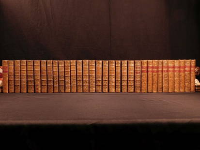
Sold20181780 1ed RARE Complete VOYAGES Maps Captain Cook Americ1780 1ed RARE Complete VOYAGES Maps Captain Cook America Explorers Africa 32v The best book of its kind! An extremely rare, 32-volume complete set of La Harpe’s ‘General History of Voyages’! ThiSee Sold Price
Sold20181780 1ed RARE Complete VOYAGES Maps Captain Cook1780 1ed RARE Complete VOYAGES Maps Captain Cook America Explorers Africa 32v The best book of its kind! An extremely rare, 32-volume complete set of La Harpe’s ‘General History of Voyages’! ThiSee Sold Price
Sold2017Levasseur: Antique Map of North America, 1840Title/Content of Map: 1840 Levasseur Map of North America - Amerique Septrentionale Date Printed: 1840 Paris Cartographer: V. Levasseur Size: 11 x 16.5 in. Condition: Excellent. Minor age toning; issuSee Sold Price
Sold2022VISSCHER, NICOLAS. Nova Tabula Geographica Complectens Borealiorem Americae Partem...VISSCHER, NICOLAS. Nova Tabula Geographica Complectens Borealiorem Americae Partem... [and] Carte Nouvelle Contenant la Partie d'Amerique la Plus Septentrionale... Large engraved two-sheet map of eastSee Sold Price
Sold2017de Vaugondy: Antique Map of New France & Great LakesMap: Partie de l'Amerique Septent. qui comprend la Nouvelle France ou le Canada Cartographer: Robert de Vaugondy Place & Date: Paris / 1755 Size: 23 5/8" x 19" Condition: outline color; some water staSee Sold Price
Sold2020Le Rouge Map of Theatre de la Guerre en AmeriqueGeorge Louis Le Rouge (fl.1740–80), "Theatre de la Guerre en Amerique," Paris: Le Rouge, 1777. A nice Revolutionary War period map of the east coast of North America from northern Florida to NeSee Sold Price
Sold2017de la Tour: Antique Map of North America, 1779Map: L'Amerique Septentrionale ou se Remarquent les Etats Unis Cartographer: Brion de la Tour Place & Date: Paris / 1779/1783 Size: 28 5/8" x 19 7/8" Condition: full wash color; cleaned and sized; minSee Sold Price
Sold2024Partie de l'Amérique Septent… la Nouvelle France. Canada. VAUGONDY 1755 mapTitle: "Partie de l'Amérique Septent… la Nouvelle France". Canada. VAUGONDY 1755 map Description: Partie de l'Amérique Septent? qui comprend la Nouvelle France ou le Canada, par le Sr.See Sold Price
Sold20222 SETS OF 2 - LA PEROUSE VOYAGE RELATED BOOKSVOYAGE OF LA PEROUS PUBLISHED IN 1798. VOYAGE IN SEARCH OF LA PEROUSE PUBLISHED IN 1800. THEY COME WITH PULL OUT MAPS.See Sold Price
Sold2016Voyages.- Dixon (Capt. George) Voyage autour du Monde,Voyages.- Dixon (Capt. George) Voyage autour du Monde, et principalement a la Cote Nord-Ouest de l'Amerique, half-title, 22 engraved maps and plates, many folding, occasional foxing, some browning aloSee Sold Price
Sold201718th Century French Map of North AmericaL’Amerique Septentrionale. Daniel de la Feuille (1640-1709). Engraved map with hand color in full. Amsterdam, 1702 or 1706. 6 x 8 inches visible, 13 x 14 1/2 inches framed. Nicely colored early 18thSee Sold Price
Sold2023FIRST EDITION OF RARE REVOLUTIONARY WAR MAPCarte Nouvelle des Possessions Angloises en Amérique dressée pour l'intellegence de la guerre, Paris 1777, Maurille Antoine Moithey, engineer. Translation: New map of the English possessionsSee Sold Price
Jun 02Schilb Antiquarian Rare Books1829 The Nun of Monza by Giovanni Rosini Italian Monastics Tuscany 3v SET$11(4 bids)
Jun 23Schilb Antiquarian Rare Books1834 Napoleonic LAW Codes Les Huit France Louis Philippe I Crime NAPOLEON$1
May 29Cedarburg Auction & Appraisals LLCSet of Four Maps Showing All of Spain and Portugal$125(2 bids)
12 hrs LeftPotter & Potter AuctionsLa Reponse de L’Amerique aux Boches. Paris: Louchet Publici...$400
Jun 09Estate Collection AuctioneerLot of 10 old photographs from the 40s & 50s "Le Corbusier" (Charles-Edouard Jeanneret)$550
Jun 07Freeman's | Hindman[MAP]. SARTINE, Antoine Plan de la Barre et du Havre de Charles-Town...1778. RARE REVOLUTIONARY WAR$1,000(1 bid)
BonhamsPAUL EMMANUEL PERAIRE (French, 1829-1893) Au Bord de la Seine (framed 69.0 x 102.5 x 10.0 cm (27...$130
May 26Whites Auctions CharlestonOscar De La Renta White Magnolia Flower Necklace and Earring Set$120(2 bids)


![[Americana] Lafayette, Marquis de Autograph Letter, signed: [Americana] Lafayette, Marquis de Autograph Letter, signed La grange, (France), 21 Novembre, 1829. One sheet, 7 7/8 x 7 3/4 in. (200 x 197 mm). Autograph letter in French, signed by the Marquis de Laf](https://p1.liveauctioneers.com/65/275517/144719964_1_x.jpg?height=310&quality=70&version=1673808587)
![[Americana] Lafayette, Marquis de Autograph Letter, signed: [Americana] Lafayette, Marquis de Autograph Letter, signed La grange, (France), 26 Sept(ember), 1829. One sheet folded to make four pages, 10 x 7 3/4 in. (254 x 197 mm). Autograph letter in French, si](https://p1.liveauctioneers.com/65/275517/144719963_1_x.jpg?height=310&quality=70&version=1673808587)


![VISSCHER, NICOLAS. Nova Tabula Geographica Complectens Borealiorem Americae Partem...: VISSCHER, NICOLAS. Nova Tabula Geographica Complectens Borealiorem Americae Partem... [and] Carte Nouvelle Contenant la Partie d'Amerique la Plus Septentrionale... Large engraved two-sheet map of east](https://p1.liveauctioneers.com/199/251723/130782443_1_x.jpg?height=310&quality=70&version=1655133895)


![[MAP]. SARTINE, Antoine Plan de la Barre et du Havre de Charles-Town...1778. RARE REVOLUTIONARY WAR (1 of 1)](https://p1.liveauctioneers.com/197/329395/177650540_1_x.jpg?height=282&quality=70&version=1715364962)


