Sold2021World War II Pictorial Battle Maps (2)VII Corps. With XIX Corps in Action From Secured Line to Victory. 2 WWII European theater maps, American troops and allies, movements with illustrations. Sights 20 1/2" x 27 1/2", overall 22" x 29".See Sold Price
Sold2018World War 2 Steel Covered Bible and Normandy InvasionWorld War Two lot composed of a pocket sized steel covered bible, given to Charles B Wagner, Charleroi, Pennsylvania, Sept 1943 and a Pittsburgh Sun Telegraph for the Normandy Invasion, 22 by 15.5 incSee Sold Price
Sold2017D-Day 1944, Wounded G.Is on the Landing Barge, Normandy1944 Original Authentic W.W.II.. U.S. Signal Corps Photo. Wounded Soldiers On The Landing Barge. Normandy Invasion. Photo Stamped for Release But Not Annotated, Not Dated. NOTE: This lot has a confiSee Sold Price
Sold2023World War II Pictorial MapLightning Strikes Twice, 78th Inf. Division, 1918 to 1945. Records movements of the division by arrows through parts of Germany. Sight 16" x 20", overall 17 1/2" x 21 1/2".See Sold Price
Sold2023WWII German Invasion of England 2nd Ed. MapsWorld War 2 german military plan maps of london, england invasion. 2nd edition, 1941. Includes 5 maps and folder. All maps are in tact, some yellowing and minor wear to fold creases due to age.See Sold Price
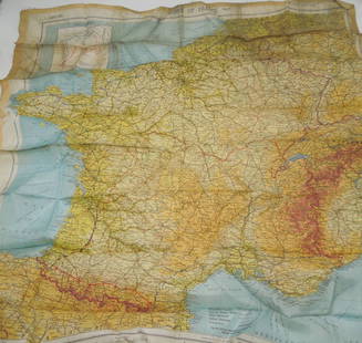
Sold2023WWII March 1944 Zones of France Silk Escape MapMarch 1944 Original silk escape map of France. This would be the type of item carried by US Paratroopers during the Invasion of Normandy, as well as US aviators flying missions over France.See Sold Price
Sold2023German invasion of Belgium and France, May-June 1940. World War 2 1953 old mapTITLE/CONTENT OF MAP: 'The German assault in the west, May-June, 1940' DATE PRINTED: 1953 IMAGE SIZE: Approx 19.0 x 25.0cm, 7.5 x 10 inches (Medium); Please note that this is a folding map. TYPE: VintSee Sold Price
Sold2023WORLD WAR 2. Maginot & Siegfried line defences. Pre-invasion of France 1940 mapTitle: WORLD WAR 2. Maginot & Siegfried line defences. Pre-invasion of France 1940 map Description: Western Front showing forests and main defences: Section 1' by George Philip & Son (March 1940). VinSee Sold Price
Sold2023WORLD WAR 2. Maginot & Siegfried lines defences. Pre-invasion. Belgium 1940 mapTitle: WORLD WAR 2. Maginot & Siegfried lines defences. Pre-invasion. Belgium 1940 map Description: Western Front showing forests and main defences: Section 2' by George Philip & Son (March 1940). VinSee Sold Price
Sold2022German invasion of Belgium and France, May-June 1940. World War 2 1953 old mapTITLE/CONTENT OF MAP: 'The German assault in the west, May-June, 1940' DATE PRINTED: 1953 IMAGE SIZE: Approx 19.0 x 25.0cm, 7.5 x 10 inches (Medium); Please note that this is a folding map. TYPE: VintSee Sold Price
Sold2019LEATHER USAF LEATHER BOMBER FLIGHT JACKETCommemorative A-2 flight jacket "50th Anniversary of Victory 1945 WWII 1995" imprinted on the inside with a coastal map of Normandy - manufactured exclusively by the Cooper Defense Contract Division sSee Sold Price
Sold2024WW2 WWII 747th armored battalion 1st engineer special brigade D-Day Ike JacketFeatures beautiful Chain stitched patches. Jacket also has 723rd tank battalion Di's and laundry number. Invasion broad arrow on ETO ribbon BarSee Sold Price
Sold2023WWII Press Photo Collection - NormandyLarge assortment of collated and archived WWII Press photos. Some very iconic showing the June 6th invasion. est 50 total in archival binders.See Sold Price
Sold2022(2) LUCIEN BOUCHER , ORIGINAL PICTORIAL MAPLUCIEN BOUCHER (1889-1971) (2) ORIGINAL AIR FRANCE COLOR LITHOGRAPH PLANISPHERE PICTORIAL TRAVEL MAPS OF THE WORLD FOR AIRLINE DESTINATIONS OF AIR FRANCE , TITLED "NOVA ET VETERA" , Sur La Vieille TerSee Sold Price
Sold2023(10) VINTAGE U.S. ARMY PATCHES(8) AIR CORPS PATCHES, & (2) RARE! WWII AIRBORNE PATHFINDER PATCHESSee Sold Price
Sold2021Pictorial Map United States IndiansIndians of the U.S.A. Louise E. Jefferson. Friendship Press, New York: 1944. Novelty map showing native American tribes. Vintage color print. 22 1/2" x 34 1/2", overall 26" x 40".See Sold Price
Sold2024Pictorial Map of the Gulf CoastPictorial Map of the Gulf Coast, 1955, drawn by Walter Overton, published by Claude Bagge, sight 13 1/2 in. x 22 in., framed. Provenance: Michael W. Murphy, El Dorado, AR.See Sold Price
Sold2021Boston Massachusetts Pictorial MapThe Colour of an Old City. Edwin Olsen and Blake Clark. Houghton Mifflin, Boston: 1926. Illustrated map. Ex library. 28 1/2" x 38".See Sold Price
Sold2020Group Collections of Photography,Letters and MapsGroup collections of Japanese occupied Nanking in World War II. 2 military maps. 2 photography album included 293 pieces photos . One Japanese Bowl.See Sold Price
Sold2021A Group of 13 maps of Chicago and Illinois, comprising:A Group of 13 maps of Chicago and Illinois, comprising: Map of Illinois. N.p.:N.d. 33 x 25.5 inches. -- Pictorial Map of Chicago. N.p.: N.d. 44 x 31.5 inches. -- Map of Chicago; [W.1/2 of S.E.1/4 SectSee Sold Price
Sold2024E.O. Goldbeck (1892-1986), Texas Oil Field PhotoVintage pictorial map of oilfields of Burkburnett, Texas, dated April 15th, 1919, marked #2, photographed by Charles Steele, framed sight: 8.5 x 60.5 in., frame: 13.5 x 65.5 in. Provenance: PropertySee Sold Price
Sold2023WWII 64th Fighter Wing A-2 JacketA fine original WWII A-2 with interesting history. All original as shown. Named to Col. George Luzerne Hart Jr.. Col. Hart was also a United States District judge for the District of Columbia, and plaSee Sold Price
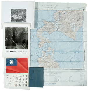
Sold2022WWII fighter pilot maps and kitHeading: (World War II) Author: Title: Fighter pilot materials from World War II Place Published: Publisher: Date Published: c.1943-1945 Description: 1 set. Includes:See Sold Price
Sold2021Elastolin German World War II Motorcycle Corps2 pieces in good condition. Some minor cracks and general wear. 70 mm metal and composition.See Sold Price
BonhamsSHACKLETON (ERNEST HENRY) The Heart of the Antarctic, being the Story of the British Antarctic E...£2,000
BonhamsILLUMINATED MANUSCRIPT - NINETEENTH CENTURY The Ballad of Chevy Chase, ILLUMINATED MANUSCRIPT, '...£500
BonhamsMACKINNON (J.P.) AND SYDNEY SHADBOLT The South African Campaign, 1879--Alexander. Photographic S...£400(1 bid)
6 days LeftJasper521885 Cram Comparison of Tall Buildings Globally -- Diagram of the Principal High Buildings of the$70
BonhamsKOLBE (PETER) Naaukeurige en uitvoerige beschryving van de Kaap de Goede Hoop... Waar by nog kom...£400


![Carroll, Lewis [Charles Lutwidge Dodgson] (1 of 1)](https://p1.liveauctioneers.com/94/330664/178342370_1_x.jpg?height=282&quality=70&version=1716466933)

