Sold2016Japanese Carved Ivory Figure of a Geisha.Japanese Carved Ivory Figure of a Geisha, Late 19th Century. Marked. Height: 12.5cm / 4.9in. This lot cannot be sold and shipped to any US state or territory.See Sold Price
Sold20221874 map of Western states & territories, MitchellInteresting and uncommon variant transitional issue that appeared in only a few editions of Mitchell’s New General Atlas. Fine 19th century engraved (lithographed) map, with original hand color. ShoSee Sold Price
Sold20241869 American Emigrants Immigration Illustrated US State MAPS Railroad Alaska1869 American Emigrants Immigration Illustrated US State MAPS Railroad Alaska Frederick Goddards “Where to Emigrate and Why” is a rare, 19th-century informational treatise designed to give hinSee Sold Price
Sold20211864 American History INDIANS Mexico TEXAS Revolution1864 American History INDIANS Mexico TEXAS Revolutionary War US Map Willson Marcus Willson’s “American History” is a mid-19th-century compendium of the history of the United States from its earlSee Sold Price
Sold2018Miller Map of the US with Presidential PortraitsMiller, William (19th Century). Map of the United States (with 13 presidential portraits + Capitol in Washington (unfinished). Engraved map. Ohio: William & Thomas Miller, 1852. 23 ½" x 31" sheet.See Sold Price
Sold20181845 Chapin's Ornamental Map Of The USAmazing 19th century Chapin's Ornamental map of the United States, dated 1845. Fair condition with expected wear for its age. Has expected discoloration, staining, tears, and other damage. Still displSee Sold Price
Sold20221856 Messages of US President 35 Atlas MAPS Florida1856 Messages of US President 35 Atlas MAPS Florida New York California Pierce Throughout the 19th-century, printed examples of Congress reports and messages of the United States Presidents were regulSee Sold Price
Sold2017Four 19th Century Maps Pertaining to the Western Unitedas follows: Geological Map of a Part of the State of California Explored in 1855 by Lieut. R. S. Williamson U.S. Top Engr (Washington: War Department, 1856); color-coded (24.5 x 19.25 in.) (Some edgeSee Sold Price
Sold2018Early 19th Century Cummings & Hilliard U.S. MapEarly 19th century Cummings & Hilliard U.S. map. Loose, unframed and not glued or mounted, etc. Sheet size 9.25" x 11.75". Good to very good condition. Provenance: Estate of Russell Johanson, RavennaSee Sold Price
Sold2018Map of the United States Solomon Schoyer 1826 EngravingWonderful Early 19th Century Antique Map of the United States - By Solomon Schoyer. Map of the United States Drawn from the Most Approved Surveys. New York: Solomon Schoyer, 1826. An Engraved foldingSee Sold Price
Sold2016Six British and American Historical EngravingsGroup of Six British and American Historical Engravings, 19th century, including "Map of The United States of America and Nova Scotia", engraved by Fenner, Sears and Company, published by T. Hinton anSee Sold Price
Sold2024Hand-Drawn Map, American School (19th century)American School (19th century), "A Map of the United States by Julia A. Benson, Aged 11," 1828, ink and watercolor on paper, sight: 19.5"h x 24"w, overall (with frame): 27.5"h x 33.5"wSee Sold Price
Sold2022Bonner's Pocket Map of the State of Georgia, 1855BONNER, William G. (19th Century). Bonner's Pocket Map of the State of Georgia. Steel engraving with original hand color. Milledgeville, GA: Wm. G. Bonner, 1855. 23 x 19 1/4? sheet, 28 1/2" x 25" framSee Sold Price
Sold2019Nine (9) Augustus Mitchell MapsCollection of late 19th century United States STATE maps including Minnesota, Iowa and Missouri, State of Maine , Illinois-Missouri-Iowa-Nebraska-and Kansas on one, Two Georgia and Alabama, ConnecticuSee Sold Price
Sold202219th Century United States & Newer U.S. Stampsand Foreign Stamps - See photos for condition and detailsSee Sold Price
Sold2016Antique US Map of Territories & Pacific States, 1865Domestic: Free ShippingItem: Old Antique Map of the Western United StatesTitle: Territories & Pacific States to Accompany "Across the Continent" by Samuel BowlesEngraver: J.H. GoldtwhaitPrinter: G.W.See Sold Price
2016Antique US Map of Territories & Pacific States, 1865Domestic: Free Shipping Item: Old Antique Map of the Western United States Title: Territories & Pacific States to Accompany "Across the Continent" by Samuel Bowles Engraver: J.H. Goldtwhait Printer: GSee Sold Price
Sold20221865 Colton Map Puzzle of the US -- Dissected Map ofTitle: 1865 Colton Map Puzzle of the US -- Dissected Map of the United States and Territories (Colton's United States of America) Cartographer: J Colton Date/Place: 1865 New York Dimensions: 10.7 X 13See Sold Price
Sold2023English Maps, Most Th. Kitchin & J. BarberA large unframed collection of 19th or 18th century maps of various English territories, about 50 in total, most by TH. Kitchin and J. Barber.See Sold Price
Sold202219th Century US Railroad political reports. 14 pieces19th Century US Railroad political reports. 14 pieces United States railway related pamphlets and ephemera. Includes Virginia and Truckee Railroad receipts, many reports from Congress on various aspecSee Sold Price
Sold2020Box Lot of ArtVarious prints, works on paper, other art. Includes Hogarth, botanicals, yachting, 4 19th century ethnographic prints, map, architecturals, U.S. Capitol, human skull etc.See Sold Price
Sold20184 19th Century Maps The World, North/South U.S.4 19th Century Maps The World, North South U.S.. 4 Maps of The World, Political Map of The Southern Division of the U.S., The Northern Division of the U.S. and Political Map of South America and AfricSee Sold Price
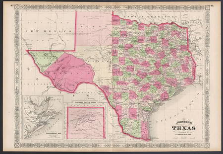
Sold2023Excellent example of Johnson’s Texas, 1866Authentic and impressive vintage map of Texas. One of the more collectible maps to be produced in the mid-19th century. A highly desirable map that details the state in full. Shows the elevated TableSee Sold Price
Sold2023James G. Blaine Portrait Political PosterLarge 19th Century Framed Portrait Print Of U.S. Secretary Of State James G. Blaine. In Frame Approximately 30.25L x 24.375W x 1.0D in. Sight Approximately 25.5L x 18.25W in.See Sold Price
Jun 09Worthington Galleries19th c. Hemisphere World Map, Hohen und Tiefen der Erde in Lambert’s Zenithal-Projection von$10