Sold20231741 antique MAP OF FRANCE REGNI GALLIEAE SEU FRANCIAE et Navarrae Tabula 18th CREGNI GALLIEAE SEU FRANCIAE et Navarrae Tabula Geographicea by Homann, Johann Baptist, 1663-1724 Nuremberg, 1741 size 20.5 by 24.5" Wear , damaged lower margin, as visible on the photos Reserve: $105.See Sold Price
Sold2024Robert De Vaugondy - Antique Map of FranceAn interesting and attractive mid 18th century map of France which was engraved by G. Rollos and published in Sieur Robert De Vaugondy.Size: 58 cm x 50 cmSee Sold Price
Sold2023A Map of New England by Mr. Dezoteux, French Army 1787France, 18th century. A map on laid paper titled 'Chart for the Journal of Mr. le Marquis. de Chastellux' by Mr. Dezoteux, a staff officer of the French Army. Good condition; sealed under a mSee Sold Price
Sold2021Jean-Baptiste Bourguignon d'Anville, 18th c. Map"Asiae, quae vulgo Minor Dicitur, et Syriae, Tabula Geographica . . .", dated for 1764, center seamed and on laid paper. Dimensions: 22" x 29", the frame 25" x 32".See Sold Price
Sold2022A late 18th century map sampler depicting southern Scotland, England and WalesA late 18th century map sampler depicting southern Scotland, England and Wales Also including the east coast of Ireland and northern France, worked on a linen group and signed and inscribed 'Wrought iSee Sold Price
Sold20241720 Tabula Geographica Homann Map of Black Sea18th Century 1720 Tabula Geographica Homann Map of Black Sea - Tabula Geographica qua pars Russiae Magnae Pontus Euxinus seu Mare Nigrum et Tartaria Minor cum finitimis Bulgariae, et Romaniae et NatolSee Sold Price
Sold201718th C. French Map w/ Oiled Paper, ex-Sotheby'sEurope, France, map from 1709 CE, oiled paper overlays from 1756 to 1763 CE, owned by Louis-Alexandre Berthier (1753 to 1815 CE), Marshal, Vice-Constable of France, and Chief of Staff (Major general)See Sold Price
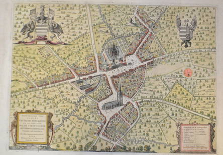
Sold201518th C French Map Of SteenvoordePLOUICH, Vedastus du -" Illvstrissimo viro domino" .The city of Steenvoorde is a small town located north of France. The city of Steenvoorde is located in the department of Nord of the french region.See Sold Price
Sold20222 Framed 18th C. Faden Maps - Greece & Denmark**Originally Listed At $200** Cartographer: William Faden (British, 1749-1836). Engraver: William Palmer (British, 1735-1812). "Graecie Antiquae et Aegaei Maris Tabula" Published by William Faden JanuSee Sold Price
Sold2022[MANUSCRIPT MAP-CARIBBEAN] Carte de L'Isle Dominique. France, likely 18th century. A manuscript map[MANUSCRIPT MAP-CARIBBEAN] Carte de L'Isle Dominique. France, likely 18th century. A manuscript map in colors on laid paper, with a decorative title cartouche and inset map of the Caribbean islands, 1See Sold Price
Sold2017Two 18th century engraved maps with hand coloringHind, Hindoostan, or India. Louis de la Rochette. Engraved map with hand color in part. London: W. Faden, c. 1790-1811. 31 x 23 inches framed. AND Africae in Tabula Geographica Delineatio. Adam FriedrSee Sold Price
Sold20191776 map of France by Zatta w/huge marginsReserve Reduced! "Lovely and large double-page copperplate engraved map of France from the most comprehensive world atlas produced in Italy in the 18th century. Original hand-color in outline with lovSee Sold Price
Sold2022Antique Map of France by Nicolas SansonAntique map of France engraved by Nicolas Sanson 1600-1667, published by Covens and Mortier in Amsterdam, 18th century. Measures 20 inches x 25 inches, in good condition.See Sold Price
Sold2020ANTIQUE MAP FRANCE SUTTON NICHOLLSFine antique map of British Isles by Sutton Nicholls 18th/19th century. Measuring framed 22 x 26 inches wide sight view 15 x 20 inches. Good condition. Printed on laid paper.See Sold Price
Sold2017Munster: Antique Map of the Iberian Peninsula, 1550Title: Tabula Europae II, Lovely mid-16th century woodblock map of the Iberian Peninsula Map maker: Sebastian Münster, Cosmographiae Universalis... Place and Year: Basel, c. 1550 Dimensions: 35.3 x 2See Sold Price
Sold2020Group of French Maps Guillaume de l'Isle SansonGroup of four 17th and 18th century French maps. Guillaume Delisle (1675-1726) hand colored engraved map of Picardie, 1748. Two maps by Nicolas Sanson (1600-1677), "Le Roayaume de France" and "GouvernSee Sold Price
Sold2023Atq JOHAN HOMANN Peru & Brazil Cartographic MapAntique circa first half of 18th century cartographic map of Peru and Brazil. Maker Homanianos Heredes (Johann Homann). Reads: Tabula America Specilialis Geographica Regni Peru, Brasilia Terra Firma.See Sold Price
Sold20201790 French Revolutions de Paris Departments France1790 French Revolutions de Paris Departments France MAPS Pas de Calais Louis Marie Prudhomme was an 18th-century French historian who is known for his satirical and sarcastic articles on the French ReSee Sold Price
Sold2020UNUSUAL GEORGE III MAHOGANY MAP OR PLAN CHEST OFUNUSUAL GEORGE III MAHOGANY MAP OR PLAN CHEST OF DRAWERS 18TH CENTURY the crossbanded top above an arrangement of six short drawers over five long drawers, on bracket feet (86cm wide, 86cm high, 49cmSee Sold Price
Sold2022A folio of 18th century and later engravings / book plates, to include Ossain at his Father'sA folio of 18th century and later engravings / book plates, to include Ossain at his Father's Tomb... after William Walker, a map of Languedoc, France, palace views, an etching depicting Classical figSee Sold Price
Sold2022Reproduction of 18th Century North America MapReproduction of 18th Century North America Map This map is a 20th century hand-colored lithographic reproduction of a 17th century map of the colonial territories held by Spain, England, and France. TSee Sold Price
Sold2023A Grouping of 17th & 18th Century Old World Maps Lot of 6Lot Includes: The English Channel, A Map of France, North American Rivers and Lakes Between Superior and Slave Lake (2), A New map of Russia in Europe, & Nouvelle Carte Du Royaume de Bengale EngraSee Sold Price
Sold2020AN ANTIQUE WILLIAM III (1689-1702) MAP, "ComitatusAN ANTIQUE WILLIAM III (1689-1702) MAP, "Comitatus Burgundiæ..." AMSTERDAM, 17TH/18TH CENTURY, "...tam in Præcipuas ejus Praefecturas quam in minores earundem Balliviatus aliasque Ditiones subjacentSee Sold Price
May 15University ArchivesRare 18th C. French Engraving Showing Chilean Hockey Player & Other Exotic Customs$140
May 16DuMouchellesFrench And American Louis XVI Period And Style Bleached Wood Armchairs, 18th & 20th C., H 40" W$150
2 days LeftJasper52Jean Baptist Cresson, Louis XV, 14 Dining Chairs, France, 18th C., Christies$44,000
5 days LeftNew England Auctions - Fred Giampietro18th c Wrought Iron French Torchiere Lighting Fixture$75(2 bids)
3 days LeftJasper5218th C Italian Classical Grand Tour Ancient City Old Ruins & Figures late 18th century$420
5 days LeftNew England Auctions - Fred GiampietroVery Large 18th C French Carved Stone Mortar$225(4 bids)
5 days LeftNew England Auctions - Fred GiampietroLarge Curved Segment from an 18th C French Granite Cider Mill$100(1 bid)
5 days LeftNew England Auctions - Fred GiampietroLarge Curved Segment from an 18th C French Granite Cider Mill$250(1 bid)


![[MANUSCRIPT MAP-CARIBBEAN] Carte de L'Isle Dominique. France, likely 18th century. A manuscript map: [MANUSCRIPT MAP-CARIBBEAN] Carte de L'Isle Dominique. France, likely 18th century. A manuscript map in colors on laid paper, with a decorative title cartouche and inset map of the Caribbean islands, 1](https://p1.liveauctioneers.com/292/250642/130213642_1_x.jpg?height=310&quality=70&version=1654271664)


