Sold202118TH C. MAP OF THE PERSIAN COAST, FRAMED"A Chart of the Coast of Persia, Guzarat & Malabar, drawn from the French Chart of ye Eastern Ocean, Publish'd in 1740, by Order of the Count de Maurepas, improved from particular Surveys and regulateSee Sold Price
Sold202118th C. French Map "Le Noveau Mexique …"Ribobert Bonne (French, 1727-1794). "Le Nouveau Mexique, Avec La Partie Septentrionale De L'Ancien, ou De La Nouvelle Espagne" Published in Paris, 1780. Among the most collected late 18th century mapsSee Sold Price
Sold201718th Century French Map of North AmericaL’Amerique Septentrionale. Daniel de la Feuille (1640-1709). Engraved map with hand color in full. Amsterdam, 1702 or 1706. 6 x 8 inches visible, 13 x 14 1/2 inches framed. Nicely colored early 18thSee Sold Price
Sold202118TH CENTURY FRENCH MAP OF SOUTHEASTERN USRigobert Bonne (French, 1727-1794). "Carte De la Partie Sud Des Etats Unis De L'Amerique Septentrionale" -circa 1780, engraving. Provenance: From the Lifetime Collection of Billy S. Arant, Jr., ChattaSee Sold Price
Sold2019.18th Century French Map of Cuba, Florida and Louisiana21 1/4 x 16 3/4 in. (framed).18th Century French Map of Cuba, Florida and LouisianaGulf of Mexico antique map Golfe du Mexique Zannoni 1762Title: Carte Geo-Hydrographique du Golfe du Mexique et de sesSee Sold Price
Sold202118TH CENTURY FRENCH MAP OF THE WORLDDimensions: Frame: H 14.5" x W 19.35" Sight: H 9.25" x W 13.75" Condition: Discolored old watercolor, some toning to mat.See Sold Price
Sold201718th C. French Map w/ Oiled Paper, ex-Sotheby'sEurope, France, map from 1709 CE, oiled paper overlays from 1756 to 1763 CE, owned by Louis-Alexandre Berthier (1753 to 1815 CE), Marshal, Vice-Constable of France, and Chief of Staff (Major general)See Sold Price
Sold2018Framed 18th C. French Map of Ancient Rome**First Time At Auction** Louis Brion de la Tour (French, 1743-1810) & Louis Charles Desnos (French, 1725-1805), "Suite De L'Histoire De Rome", ca. 1760 to 1770. Copperplate engraved with original hanSee Sold Price
Sold201518th C French Map Of SteenvoordePLOUICH, Vedastus du -" Illvstrissimo viro domino" .The city of Steenvoorde is a small town located north of France. The city of Steenvoorde is located in the department of Nord of the french region.See Sold Price
Sold2021Pair 18th C French Maps after the AntiqueTo include "A View of the Town-House or Guild Hall of Paris" and "Vue de Chateau Royal D'amboise" : mid 20th century prints after the antique, housed in concave giltwood frames. Copperplate engravingsSee Sold Price
Sold2020Group of French Maps Guillaume de l'Isle SansonGroup of four 17th and 18th century French maps. Guillaume Delisle (1675-1726) hand colored engraved map of Picardie, 1748. Two maps by Nicolas Sanson (1600-1677), "Le Roayaume de France" and "GouvernSee Sold Price
Sold2022GUILLAUME DE LISLE (1675-1726), AN 18TH CENTURY FRENCHGUILLAUME DE LISLE (1675-1726), AN 18TH CENTURY FRENCH COLONIAL MAP, "Carte de la Louisiane et de Cours du Mississipi," AMSTERDAM, CIRCA 1727, engraving on paper with ink inscriptions, after GuillaumeSee Sold Price
Sold2023Antique 18th C Map of the Gulf of Mexico, M. Rizzi ZannoniM. RizziZannoniMapofthe Gulfof Mexico, Caribbean, and parts of Central America, hand-colored engraving on paper, titled "Carte Geo-Hydrographique du Golfe de Mexico Et Des Ses Isles". Published in ParSee Sold Price
Sold202318TH C. MAP OF THE COAST OF BRAZIL BY BELLIN"Carte du Bresil, Prem Partie. Depuis la Riviere des Amazones jusqua la Baye de Tous les Saints, Pour Servir a l'Histoire Generale des Voyages" by Jacques-Nicolas Bellin, 1780 (undated). In oak half-rSee Sold Price
Sold2023LATE. 18TH C. PARTIAL MAP OF THE ATLANTIC COASTAntonio Zatta (Italian 1757-1797), "Parte Orientale della Florida, della Georgia, e Carolina Meridionale" late 18th century, etching on paper depicting the Atlantic coast during the American Civil WarSee Sold Price
Sold2018FRENCH 18TH CENTURY MAP OF BOSTON, MASSACHUSETTSFRENCH 18TH CENTURY MAP OF BOSTON, MASSACHUSETTS, on laid paper, title in top center "PLAN DE BOSTON", most likely Georges-Louis Le Rouge (French, c. 1712 to 1790), probably after John Bonner (EnglishSee Sold Price
Sold202118th Century Florida Louisiana Coast Map - JefferysCarte de la Floride occidentale et Louisiane. La peninsule et golfe de la Floride ou canal de Bahama avec les isles de Bahama. Contributors - Le Rouge, Georges-Louis, Jefferys, Thomas, -1777. PrintedSee Sold Price
Sold20231748 Map of North America, Comprehending 'The Course to Ohio'America, 18th century. An early map of the eastern coast, detailing New England, New York, and more. No maker marks present. Overall good condition; complete on laid paper.See Sold Price
Sold2017GEORGE-LOUIS LE ROUGE (FRENCH, 18TH CENTURY)GEORGE-LOUIS LE ROUGE (FRENCH, 18TH CENTURY) REVOLUTIONARY WAR MAP hand-colored engraving on laid paper, "Theatre du Guerre en Amerique", published in Paris 1777, includes a small vignette of NiagaraSee Sold Price
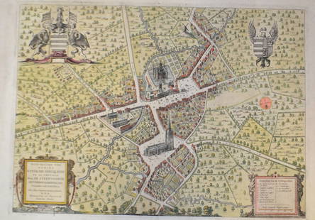
Sold2018Antique French Copper Engraved Colored Map, Amsterdam18th century antique French copper engraved and hand colored maps of Amsterdam, Netherlands titled "Lemouicum, Auctore Jo. Faiano M.L. - Lymosin [on sheet with] Topographia Limaniae, Auctore GabrieleSee Sold Price
Sold202418th c. French Bronze Relief Bronze Plaque18th Century French Bronze Relief Plaque Depicting Muisketers Fighting with Swords in Palace Possibly Assassination Fighting Scene 6 1/2"L x 5"W In Overall Good Condition Please look at Photos CloselySee Sold Price
Sold2022A late 18th century map sampler depicting southern Scotland, England and WalesA late 18th century map sampler depicting southern Scotland, England and Wales Also including the east coast of Ireland and northern France, worked on a linen group and signed and inscribed 'Wrought iSee Sold Price
Sold20201739 Astronomy Galileo Telescope Illustrated Zodiac MAP1739 Astronomy Galileo Telescope Illustrated Zodiac MAPS Optics Pluche Noël-Antoine Pluche was an early 18th-century French priest and historian who is most remembered today for his landmark work ofSee Sold Price
6 days LeftHolabird Western Americana CollectionsFrench Map of America Southwest & Mexico [179298]$170
5 days LeftJasper52Partie Occidentale de l’Afrique. West Africa coast Canary islands BONNE 1788 map$15
5 days LeftJasper52Royaumes, Etats et Pays de la Haute Guinée. Gulf of Guinea. BONNE 1788 old map$20
5 days LeftJasper52L'Afrique Françoise ou du Senegal'. French West Africa. DE L’ISLE 1727 map$100
5 days LeftJasper52Côte occidentale de l'Afrique. W Africa.Senegal Gambia rivers.D’ANVILLE 1751 map$85
Jun 14DuMouchellesRigobert Bonne (French, 1727-1794) Hand Colored Engraving Ca. 18th Century, Les Etats Unis De$50(1 bid)
Jun 15Riverfront Auctions'1785 Bocage Map of the City of Athens in Ancient Greece' Par M. Barbié du Bocage$5(1 bid)
Jun 30Global Auctions CompanyCharles Dupuis French 18th century, Pair Hand Colored Engravings, Architectural$400
3 days LeftHeritage Auctions61169: A French Aubusson Tapestry, mid-18th century 97 $2,200
3 days LeftHeritage Auctions61106: A French Louis XV Bronze-Mounted Parquetry Commo$1,500(1 bid)


![Antique French Copper Engraved Colored Map, Amsterdam: 18th century antique French copper engraved and hand colored maps of Amsterdam, Netherlands titled "Lemouicum, Auctore Jo. Faiano M.L. - Lymosin [on sheet with] Topographia Limaniae, Auctore Gabriele](https://p1.liveauctioneers.com/6377/128239/65869733_1_x.jpg?height=310&quality=70&version=1540604375)


![French Map of America Southwest & Mexico [179298] (1 of 1)](https://p1.liveauctioneers.com/2699/331495/178785763_1_x.jpg?height=282&quality=70&version=1717094933)