Sold2017Rand McNally Map India, Burma, Nepal and Ceylon, 1898Map: 1898 Rand McNally India, Burma, Nepal and Ceylon -- India Cartographer: Rand McNally Year / Place: 1898, Chicago Map Dimension: 26.2 X 19.2 in. A very nice map of South East Asia. Highly detailedSee Sold Price
Sold20191834 SDUK Map of South Africa -- South Africa CompiledTitle/Content of Map: 1834 SDUK Map of South Africa -- South Africa Compiled from the M.S. Maps in the Colonial Office Captn. Owen's Survey &c Date: 1834, London Cartographer: SDUK Size: 12.3 x 15.5 iSee Sold Price
Sold2024MAP, South Africa, UllmannSouth Africa. Ernest Ullmann, Tourist Map of South Africa, 1937 (dated). Printed Color. This charming tourist map of South Africa was created by Ernest Ullmann for the Publicity and Travel DepartmentSee Sold Price
Sold20191975, SILVER (.800) RAND, SOUTH AFRICA, NNC-PR 67 DCAM,1975, SILVER (.800) RAND, SOUTH AFRICA, NNC-PR 67 DCAM, BEAUTIFUL COIN!See Sold Price
Sold2022Kelly, Christopher 1816 Map. South Africa"Colony of Good Hope &c" Copper Engraved Map Published 1816, London for "A New and Complete System of Universal Geography" by Christopher Kelly. Maps Engraved by Findlay, Wallis and others. Paper SizeSee Sold Price
Sold2022Kelly, Christopher 1836 Antique Map. South Africa"Colony of Good Hope &c" Copper Engraved Map Published 1836, London for "A New and Complete System of Universal Geography" by Christopher Kelly. Maps Engraved by Findlay, Wallis and others. Paper SizeSee Sold Price
Sold20221898 South Africa (Z.A. Republic) Penny.1898 South Africa (Z.A. Republic) Penny.See Sold Price
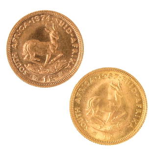
Sold2022A Lot of 2 Gold CoinsIncluding 1R Rand, South Africa 1967 and 1R Rand 1974, 91.7% Gold, total weight is 8 grams.See Sold Price
Sold2017Tallis: Antique Map of South Africa, Cape Colony, 1853Map: South Africa: Cape Colony Date Printed: 1853 Cartographer: Tallis Material/Medium: lithograph Size: 10 3/4" x 14" Original lithograph by John Tallis & Company of London, c. 1853. Map vignettes feSee Sold Price
Sold2017Tallis: Antique Map of South Africa, 1853Map: South Africa: Natal & Kaffraria Date Printed: 1853 Cartographer: Tallis Material/Medium: lithograph Size: 10 3/4" x 14" Original lithograph by John Tallis & Company of London, c. 1853. Map vignetSee Sold Price
Sold2020"South Africa" by John Thomson. Graaff ReynetTITLE/CONTENT OF MAP: 'South Africa' A map of South Africa, focused on the Western Cape The top image on the right hand side shows the entire map. To view a close up of the map showing the level of prSee Sold Price
Sold2024South Africa 1892Title/Content of Map: South Africa 1892 Date Printed: 1892 Material/Medium: Paper Size: Approx. 14"x11" Additional Info: Iliff's Imperial Atlas of the World. Publisher: J. A. Stewart & Co, Stockton, CSee Sold Price
Sold2023South Africa 1886Title/Content of Map: South Africa 1886 Date Printed: 1886 Material/Medium: paper Size: approx.13.5x10.5 inches The Peoples Illustrated Atlas Reserve: $35.00 Shipping: Domestic: Flat-rate of $15.00 tSee Sold Price
Sold2021South Africa 1900Title/Content of Map: South Africa 1900 Date Printed: 1900 Material/Medium: paper Size: approx. 10x13 inches Additional Info: Mast, Crowell & Kirkpatrick - edges repaired Reserve: $30.00 Shipping: DomSee Sold Price
Sold2019Maps 19th Century. Mixed Lot of 7Lot of 7 Lithographed and Engraved Maps. Incl Europe Continent, Italy (Part Map) South Africa, Worcester/Gloucester, Huntingdonshire, Africa and UK. Examples by Stieler, Weekly Dispatch, Guthrie, JohnSee Sold Price
Sold2020Maps 19th Century. Mixed Lot of 8Lot of 8 Lithographed and Engraved Maps. Incl Europe Continent, Italy (Part Map) South Africa, Worcester/Gloucester, Huntingdonshire, Asia and UK. Examples by Stieler, Weekly Dispatch, Goldsmith, JohnSee Sold Price
Sold2018Maps 19th Century. Mixed Lot of 7Lot of 7 Lithographed and Engraved Maps. Incl Europe Continent, Italy (Part Map) South Africa, Worcester/Gloucester, Huntingdonshire, Africa and UK. Examples by Stieler, Weekly Dispatch, Guthrie, JohnSee Sold Price
Sold20181899 Stanford Map of South Africa During the Boer WarTitle/Content of Map: 1899 Stanford Map of South Africa During the Boer War -- The Crisis in South Africa. Stanford's New Map of the Orange Free State, the Southern Part of the South African Republic,See Sold Price
Sold20211855 Map of South AfricaAuthor: Colton Title: 1855 Map of South Africa Medium: Ink on Paper Dimensions: 18.5"X16" Map of the South Africa dated 1855. Engraved and published by J.H. Colton in New York. Color coded for territoSee Sold Price
Sold20231892 Black Map of South AfricaTitle: 1892 Black Map of South Africa Cartographer: A&C Black Year / Place: 1892, Edinburgh Map Dimension (in.): 16.4 X 22.2 in. This is a highly detailed map of South Africa. Shown are the color-codeSee Sold Price
Sold20181882 Brockhaus Map of South Africa -- Karte derTitle/Content of Map: 1882 Brockhaus Map of South Africa -- Karte der Kapstaaten Date: 1882 Leipzig Cartographer: F Brockhaus Size: 11 x 8.4 in. A very nice map of South Africa, with great deal of polSee Sold Price
5 days LeftJasper521898 Rand McNally Map of Texas [verso] Indian Territory and Oklahoma -- Texas [verso] Oklahoma and$70


![1898 Rand McNally Map of South Africa -- [South Africa] First Image](https://p1.liveauctioneers.com/5584/323741/174232651_1_x.jpg?height=300&quality=1&version=1711483486&width=300)
![1898 Rand McNally Map of South Africa -- [South Africa] First Image](https://p1.liveauctioneers.com/5584/323741/174232651_1_x.jpg?height=300&quality=95&version=1711483486&width=300)


![1898 Rand McNally Map of Texas [verso] Indian Territory and Oklahoma -- Texas [verso] Oklahoma and (1 of 2)](https://p1.liveauctioneers.com/5584/328338/176911581_1_x.jpg?height=282&quality=70&version=1715113718)


