Sold20231898 Walker Trolley Map & View of New England Center of BostonOriginal map Harvard Map Collection ca. 1905See Sold Price
Sold2020Boston, 1898Title/Content of Map: Boston Date Printed: 1898 Material/Medium: paper Size: approx. 11x14 inches Rand McNally & Co. Atlas of the World Reserve: $20.00 Shipping: Domestic: Flat-rate of $12.00 to anywSee Sold Price
Sold20221898 Map of WorcesterMatte 24" x 36". Map 21" x 31" Please see photos and come to the 2 day preview for condition.See Sold Price
Sold20211898 Map of IcelandAuthor: Cram Title: 1898 Map of Iceland Medium: Ink on Paper Dimensions: 14.5"X11" Map of Iceland dated 1898. Printed and published by George Cram in Chicago. Part of his World Atlas. Key lower right.See Sold Price
Sold20201898 Map of CaliforniaAuthor: Cram Title: 1898 Map of California Medium: Ink on PaperDimensions: 14.5"X22" Map of California dated 1898. Engraved and published by George Cram in Chicago. Double folio map. Key lower right.See Sold Price
Sold2024West India Islands. West Indies Caribbean Jamaica Antilles. BARTHOLOMEW 1898 mapTITLE OF MAP (NOT PRINTED ON THE PAGE):'West India Islands' DATE PRINTED: 1898 IMAGE SIZE: Approx 29.5 x 40.5cm, 11.5 x 16 inches (Large) TYPE: Antique atlas map CONDITION: Good; suitable for framing.See Sold Price
Sold2024Asia. Arabia. Siam includes Laos. Abou Thubbi (Abu Dhabi) BARTHOLOMEW 1898 mapTITLE OF MAP (NOT PRINTED ON THE PAGE):'Asia' DATE PRINTED: 1898 IMAGE SIZE: Approx 44.5 x 57.0cm, 17.5 x 22.25 inches (Large); Please note that this is a folding map. TYPE: Antique atlas map CONDITIOSee Sold Price
Sold20201898 Map of the Philippine IslandsAuthor: Cram Title: 1898 Map of the Philippine Islands Medium: Ink on PaperDimensions: 14.5"X22" Map of the Philippine Islands dated 1898. Engraved and published by George Cram in Chicago. Double foliSee Sold Price
Sold2023SOUTH AMERICA NW. Shows Colombian & Peruvian claims on Ecuador. Lima 1898 mapTitle: SOUTH AMERICA NW. Shows Colombian & Peruvian claims on Ecuador. Lima 1898 map Description: South America (Section 1); Inset maps of Lima' by John Bartholomew (1898). Antique colour map, 43.0 xSee Sold Price
Sold2023SOUTH AMERICA NE. Brazil. Guyana. inset Rio de Janeiro. BARTHOLOMEW 1898 mapTitle: SOUTH AMERICA NE. Brazil. Guyana. inset Rio de Janeiro. BARTHOLOMEW 1898 map Description: South America (Section 2); Inset map of Rio de Janeiro' by John Bartholomew (1898). Antique colour map,See Sold Price
Sold2022Lot 2, Vintage Scratch Map & Boston Block Print1 vintage scratch map of the world. Approximately 23 x 32 inches. 1 The town of Boston in New England by John Bonner, 1722. Depicting a birds eye view map of the city of Boston in 1722. ApproximatelySee Sold Price
Sold2023American Rubber Co. Promotional Card 1898 BostonA card promoting the American Rubber Co. measuring 6 1/4" x 3 1/2". We believe this is from 1898 based on the small calendar on the wall behind the woman who is putting on her "American" Rubbers overSee Sold Price
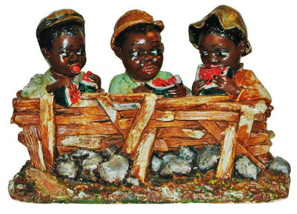
Sold20211898 Black Boys & Watermelon Plaster Figure GroupPainted Molded Plaster 17” by 11” Figure Grouping. Three black boys eating watermelon. Copyright 1898 Boston.See Sold Price
Sold2018SDUK: Antique Map of Boston & Charlestown, 1847Title/Content of Map: 'BOSTON WITH CHARLESTOWN AND ROXBURY' Antique town city map plan Date Printed: 1847 Image Size: Approx 39.0 x 32.0cm, 15.25 x 12.75 inches (Large) Type: Antique steel engraved maSee Sold Price
Sold2017Boston Harbor and the North ShoreTitle/Content of Map: Boston Harbor and the North Shore Date Printed: 1907 Cartographer: Walker Lithograph and Publishing Company Size (in): 20 x 13 Orginal antique birdseye view folding map of BostonSee Sold Price
Sold2017Map of Boston Harbor, 1882Map: Boston Harbor Cartographer: Walker-Potter, British Admiralty Place & Date: London / 1882 Size: 38 3/4" x 26 1/2" Condition: b&w, minor marginal nicks A spectacularly detailed British Admiralty chSee Sold Price
Sold2017Colton: Antique Map of Boston, 1861Title/Content of Map: Boston by Colton Date Printed: 1861 Cartographer: J.H. Colton Material/Medium: Paper Size: 14" x 17 1/4" Hand colored, steel engraved. From Colton's 'General Atlas'. Published inSee Sold Price
Sold2017Civil War Era Map of the United StatesMap of the United States and Territories. Henry F. Walling (1825 - 1889) & Ormando W. Gray (fl. 1860 – 1880). Lithographed Map. Boston, 1871. 17 x 25 1/2 inches sheetSee Sold Price
Sold2017Map of Hawaii and the Philippines, 1898Map: 1898 Map of Hawaii and the Philippines -- The Philippine Islands and Hawaii Cartographer: Century Co. Year / Place: 1898, New York Map Dimensions: 10.4 x 14.7 in. An unsual, rare and interestingSee Sold Price
Sold2020Boston 1889Title/Content of Map: Boston 1889 Date Printed: 1889 Material/Medium: paper Size: approx. 10.5x 14.5 inches Additional Info: Cram's Unrivaled Atlas of the World Reserve: $20.00 Shipping: Domestic: FlaSee Sold Price
Sold2020Boston 1892Title/Content of Map: Boston 1892 Date Printed: 1892 Material/Medium: Paper Size: approx. 11x14.5 inches Additional Info: Illif's Imperial Atlas of the World Reserve: $20.00 Shipping: Domestic: Flat-rSee Sold Price
Sold2018Vintage Auto Advertising and Map LotGMC, Gulf, Esso, Shell, Sunoco, Plymouth, 1940 Classical Lands Mediterranean Map, 1939 Atlantic Ocean map, Boston and moreSee Sold Price
Sold2017Mitchell: Antique Map of Boston, 1869Title/Content of Map: Boston by Mitchell Date Printed: 1869 Cartographer: Augustus S. Mitchell Material/Medium: Paper Size: 12" x 15" Hand colored engraved Map. From 'Mitchell's New General Atlas.' PuSee Sold Price
Sold2020American flag catalog, 1898Flyer advertising the 1898 Boston Regalia Company flag catalog. 5"x7".See Sold Price
7 days LeftJasper52NILE VALLEY. Sudan Tanzania Ethiopia Uganda Lake Victoria. Britannica. 1898 map$15
7 days LeftJasper52COLONIAL CENTRAL AFRICA. Congo German East Africa Rhodesia. BARTHOLOMEW 1898 map$40
6 days LeftJasper521898 Cram Map of Victoria [verso] South Australia and Northern Terr. [verso] Queensland -- Map of$40
7 hrs LeftForum AuctionsTolkien (J.R.R.) The Hobbit; or There and Back Again, first American edition, first state, Boston£850(2 bids)
Jun 08Simpson Galleries, LLC.J.H. Young (1792-1870) AN AMERICAN FEDERAL PERIOD MAP, "Mitchell's Travellers Guide Through the$500
Jun 06Freeman's | HindmanTHOREAU, Henry David (1817-1862). Walden: or, Life in the Woods. Boston: Ticknor & Fields, 1854.$3,000
Jun 06Freeman's | HindmanTHOREAU, Henry David (1817-1862). [The Season Books]. Early Spring in Massachusetts. 1881. --$400
Jun 23Schilb Antiquarian Rare BooksUS War w/ SPAIN 1898 1ed Puerto Rico CUBA Philippines MAPS Russell Illustrated$76(4 bids)


![1898 Cram Map of Victoria [verso] South Australia and Northern Terr. [verso] Queensland -- Map of (1 of 3)](https://p1.liveauctioneers.com/5584/331064/178466379_1_x.jpg?height=282&quality=70&version=1716924723)


![THOREAU, Henry David (1817-1862). [The Season Books]. Early Spring in Massachusetts. 1881. -- (1 of 1)](https://p1.liveauctioneers.com/197/329405/177652637_1_x.jpg?height=282&quality=70&version=1715364568)


