Sold2022THE LETTER THAT ARRIVED TOO LATE: AN IMPORTANT LEE LETTER TO UNION COMMANDER U.S. GRANT AT COLD ...THE LETTER THAT ARRIVED TOO LATE: AN IMPORTANT LEE LETTER TO UNION COMMANDER U.S. GRANT AT COLD HARBOR. LEE, ROBERT E. 1807-1870. Letter Signed ('R.E. Lee') to U.S. Grant from the battlefield at ColdSee Sold Price
Sold2015Roy Llichtenstein oilRoy Lichtenstein (American 1923-1997)- ''The Capture of Roanoke Island''- oil on canvas, 1953, signed Lichtenstein upper right, titled upper left. 36 x 42'' Literature: E. Busche- 'Roy Lichtenstein: DSee Sold Price
Sold2021Brant Decoy, William “Tucker” Daniels (1879-1953)William “Tucker” Daniels (1879-1953) Wanchese, NC, c. 1910 17 1/2 in. long Daniels was a fisherman, hunter, guide, and decoy maker who spent most of his life on Roanoke Island. This decoy displaysSee Sold Price
Sold2024Simmons water colorSimmons water color, "The Old Parker House, Roanoke Island, NC, on paper, a country home in the summer, 1954, image - 13 1/2" x 20, matted in wood 25" x 31" frame. Condition: very good, not examined oSee Sold Price
Sold202370304: A Marshall Islands Navigation Map Micronesia, 1A Marshall Islands Navigation Map Micronesia, 19th century Constructed of coconut palm leaf midribs and shells. Such maps or charts were for navigating specific atolls and islands in MicrSee Sold Price
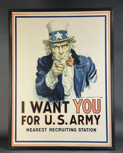
Sold2021Flagg. I Want You For U.S. Army Poster. 1917.Flagg, James Montgomery (American, 1870-1960). "I WANT YOU FOR U.S. ARMY". 1917. Published by Leslie Judge co. NY. Signature in plate. Framed: 42" x 31 1/2". Condition: Fine. Linen-backed. Some restorSee Sold Price
Sold2020WWII 8th AAF General Auton A-2 Flight Jacket & PhotosGroup from US Army Air Forces Brigadier General Jesse Auton that was obtained via a relative of his out of the trunk of a car approximately 25 years ago and has been together ever since. During WWII iSee Sold Price
2021James Montgomery Flagg US Army Recruitment Poster(America, 1870-1960) German Re Print by Drukkerij De Lange/van KLeer of the original "I Want You for U S Army' Poster. 1917 published by Leslie Judge, New York. Some scattered stains and a tear at topSee Sold Price
Sold2022Douglas MacArthur Signed PhotographVintage matte-finish 10 x 8 U.S. Army photograph of General MacArthur wading ashore Leyte Island in the Philippines in October 1944, signed neatly over his person in fountain pen. Reverse bears U.S. ASee Sold Price
Sold20151845 MITCHELL'S REFERENCE & DISTANCE WALL MAP U.S.SHOWING MITCHELL'S 1845 REFERENCE AND DISTANCE WALL MAP OF THE UNITED STATES WITH GENERAL MAP OF THE US WITH CONTIGUOUS BRITISH AND MEXICAN POSSESSIONS.PHILADELPHIA : S. AUGUSTUS MITCHELL COPPER-ENGRASee Sold Price
Sold2023WWII U.S MILITARY WAR MAPS OF FRANCE/BELGIUM - (9)171281 WWII U.S MILITARY WAR MAPS OF FRANCE/BELGIUM - (9) WWII U.S. military war maps of France/Belgium to include one sheet 79 Defenses Vierville-Sur-Mer France (12500) war map, two sheet 31/18 S.E.See Sold Price
Sold2023WWII U.S. MILITARY FIELD MAPS 1939-1945 - (4)170301 WWII U.S. MILITARY FIELD MAPS 1939-1945 - (4) WWII U.S. military field maps 1939- 1945 to include one East and West Omaha beach scanned "Bigot" Field maps, one France (12500) Isigny field map,See Sold Price
Sold2020Mitchell Map of Western U.S.*** START PRICE IS THE RESERVE *** [America] MITCHELL, Samuel Augustus (1792-1868). A New Map of Texas, Oregon and California with the Regions Adjoining. Engraving with original hand color, with origiSee Sold Price
SoldWW1 German 1917 Map of BelgiumWW1 German 1917 Map of Belgium, interesting map of a scale 1:100,000, produced for the German 4th Army (4.Armee). Marked to the top “Geheim” meaning secret. Map shows the positions of theSee Sold Price
Sold1919 Map of European Russia1919 Map of European Russia: Map showing the lines held by the Soviet Army on June 5th 1919, done by N.R.E.F. Mapping Section, in folded condition, size 40 cm x 42 cm.See Sold Price
Sold2022MACLEOD, Alexander Samuel (1888-1956). A Map of Honolulu an...MACLEOD, Alexander Samuel (1888-1956). A Map of Honolulu and the Sandwich Islands which we now call the Hawaiian Islands. 1927. New York: Henry M. Snyder. Scarce and detailed map of Honolulu, with anSee Sold Price
Sold2023Rare 1925 Map of The Town and Harbor of Nantucket by Phillip L. HallRare 1925 Map of The Town and Harbor of Nantucket by Phillip L. Hall, whimsical map showing the town, harbor, ships, aircraft, and prominent landmarks of the island. Overall 23 in. x 15 in.See Sold Price
Sold2022MS. plat map of S.F. Pueblo Lands 1884Heading: -1884 Author: von Leicht, Ferdinand Title: Plat of the Pueblo Lands of San Francisco finally confirmed to the City of San Francisco Surveyed under instructions from the U.S. Surveyor GeneralSee Sold Price
Sold2017William Faden, rare Revolutionary War Map of NYWilliam Faden, rare Revolutionary War Map of NY, William Faden (British, 1749-1836), "A Plan of the Operations of the Kings Army under the Command of General Sr. William Howe, K.B. in New York and EasSee Sold Price
Sold2022Wackenreuder map for 1861 Langley Directory of SFHeading: -1861 Author: Wackenreuder, Vitus Title: City and County of San Francisco. Compiled from official surveys, and sectionized in accordance with U.S. Surveys Place Published: San Francisco PubliSee Sold Price
Sold2022Jose Formoso Reyes Nantucket Friendship Basket with Carved Nantucket Island on the LidJose Formoso Reyes (1902-1980) Nantucket Friendship Basket with Carved Nantucket Island on the Lid, signed upon the base "Made in Nantucket, Jose Formoso Reyes 1966" with outline map of Nantucket IslaSee Sold Price
Sold2022Cadastral map of land in Portola district SF 1869Heading: -1869 Author: Title: Plan of the Haley Purchase, west of and adjoining the Hudson Tract. To be sold by Maurice Dore & Co. April 27th, 1869. Title U.S. Patent, and Bernal Rancho Place PublishSee Sold Price
Sold2023Cabinet photo of Lincoln at Antietam BattlefieldCabinet photo of Pres. Lincoln meeting with Gen. McClellan and staff at Headquarters Army of the Potomac, previous to reviewing the troops and the Battle-Field of Antietem, 3d, Oct. 1862, Brady's AlbuSee Sold Price
Sold2024Map of United States of North America, 1785Map of United States of North America, 1785, The Royal Islands of Newfoundland. 26 3/4 x 32 3/4 in framed. 19 x 25 in unframed.Local Pick up call one day before to make an appointment. TO SHIP THIS ITSee Sold Price
13 hrs LeftFreeman's | Hindman[CIVIL WAR]. Archive of items related to Elisha Hunt RHODES (1842-1917), 2nd Rhode Island Volunteer$750
Jun 23Schilb Antiquarian Rare Books1877 Geology Geography Surveys 1ed Nevada Wyoming Utah George Wheeler US West 2v$1
13 hrs LeftFreeman's | Hindman[CIVIL WAR - GETTYSBURG]. CDV of Captain Elon Farnsworth, KIA at Gettysburg. Washington, DC:$1,000
13 hrs LeftFreeman's | Hindman[CIVIL WAR - GETTYSBURG]. CDV of General Gabriel Paul, blinded at Gettysburg.$200
Jun 08Simpson Galleries, LLC.J.H. Young (1792-1870) AN AMERICAN FEDERAL PERIOD MAP, "Mitchell's Travellers Guide Through the$500
Jun 08Harris Toy and Train AuctionsLionel Postwar HO Gauge Santa Fe B Unit X2/Santa Fe A Unit X2/Pennsylvania Dump Car X2/US Army Flat$20
3 days LeftCarlsen Gallery, Inc.US C.1870 -1880 INDIAN WARS FIELD BLOUSE, BELT, CARTRIDGE BOX, BAYONETTE & SCABBARD & CANTEEN ON$275(2 bids)
2 days LeftBlack Hills Curio CompanyWorld War II U.S. Navy Aviation Bullion Eagle U.S. Marine Corps Jacket/ 4 Military Hats Vietnam$50
3 days LeftBroward Auction GalleryArthur Diehl (MA,NY,UK,1870-1929) watercolor painting antique$10(1 bid)


![Mitchell Map of Western U.S.: *** START PRICE IS THE RESERVE *** [America] MITCHELL, Samuel Augustus (1792-1868). A New Map of Texas, Oregon and California with the Regions Adjoining. Engraving with original hand color, with origi](https://p1.liveauctioneers.com/1968/163248/82424595_1_x.jpg?height=310&quality=70&version=1583340284)


![[CIVIL WAR]. Archive of items related to Elisha Hunt RHODES (1842-1917), 2nd Rhode Island Volunteer (1 of 6)](https://p1.liveauctioneers.com/197/329785/177758366_1_x.jpg?height=282&quality=70&version=1715625218)

![[CIVIL WAR - GETTYSBURG]. CDV of Captain Elon Farnsworth, KIA at Gettysburg. Washington, DC: (1 of 2)](https://p1.liveauctioneers.com/197/329785/177758276_1_x.jpg?height=282&quality=70&version=1715625218)
![[CIVIL WAR - GETTYSBURG]. CDV of General Gabriel Paul, blinded at Gettysburg. (1 of 2)](https://p1.liveauctioneers.com/197/329785/177758280_1_x.jpg?height=282&quality=70&version=1715625218)


