Sold2023EUROPE/HOLY ROMAN EMPIRE. at the time of the Third Crusade 1190 1902 old mapTITLE/CONTENT OF MAP: 'Europe at the time of the Third Crusade 1190' DATE PRINTED: 1902 IMAGE SIZE: Approx 25.0 x 34.0cm, 9.75 x 13.5 inches (Large) TYPE: Antique colour map. This map was published inSee Sold Price
Sold2023Eisenhower, Crusade in Europe, 1948, WWII Memoirs, illustrated, Maps"Crusade in Europe" by Dwight David Eisenhower, published by Doubleday, Garden City, New York, 1948. Hard boards, original brown cloth with lettering on front board and spine, 5.3/4" x 8.3/4"; endpapeSee Sold Price
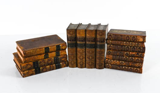
Sold2022GROUPING OF ANTIQUE LEATHER-BOUND BOOKSIncluding (7) vol. "Epochs of History" 1899, with fold-out maps of Europe; (4) vol. Dickens' Works, 1869, plus some miscellaneous volumes. Dimensions: (Overall linear) H 8.75" x W 19" Condition: As isSee Sold Price
Sold2017Crusade in Europe, First EditionCrusade in Europe. Author: Dwight D. Eisenhower. Doubleday, 1948. First Trade Edition. Illustrated with photos and maps. 8V0. Please note that this lot has a confidential reserve. When you leave a bidSee Sold Price
Sold2020AN ANTIQUE MAP, "Europe (Evrop)," JOHN SPEED,AN ANTIQUE MAP, "Europe (Evrop)," JOHN SPEED, CARTOGRAPHER, 1626-1676, hand-colored engraving on paper, Abraham Goos (1589-1643), engraver, published for merchants Thomas Basset and Richard Chiswell iSee Sold Price
Sold20241869 Map of the Railroads of New Jersey1869 Map of the Railroads of New Jersey A framed Map of the Railroads of New Jersey dated 1869 from the Pennsylvania Railroad General Office Library. The 19 1/2" x 27 1/2" wooden frame holds a map takSee Sold Price
Sold20231850s Dufour ATLAS 42 HUGE MAPS Europe ENORMOUS & RARE Geography Cartography1850s Dufour ATLAS 42 HUGE MAPS Europe ENORMOUS & RARE Geography Cartography Adolphe Dufour was a 19th-century French cartographer and map maker known for his highly detailed maps of European cities aSee Sold Price
Sold20212) STIELER & MITCHELL MAPS EUROPE, TURKEY & GREECE(lot of 2) Framed maps, including: (1) engraving with hand coloring on paper, German map of Europe, Turkey, Greece, and the Ionian Islands, from "Stielers Schul-Atlas," published by Justus Perthes, GoSee Sold Price
Sold2023Oceanica exhibiting its various divisions… Pacific Hawaii. MITCHELL 1869 mapTITLE/CONTENT OF MAP: 'Map of Oceanica, Exhibiting its Various Divisions, Island Groups &c // Map of the Sandwich Islands' DATE PRINTED: 1869 IMAGE SIZE: Approx 28.5 x 36.0cm, 11.25 x 14.25 inches (LaSee Sold Price
Sold2021de Fer, Nicolas 1717 Antique Map. Europe"L'Europe Suivant les Nouvelles Observations" Copper Engraved Map Published 1717, Paris for "Introduction a la Geographie" by Nicolas de Fer. Folds as issued. Paper Size: 14 x 10 inch (36 x 25cm) GoodSee Sold Price
Sold2023South America. Proposed Atrato-Inter-Oceanic Canal Routes. MITCHELL 1869 mapTitle: South America. Proposed Atrato-Inter-Oceanic Canal Routes. MITCHELL 1869 map Description: Map of South America showing its Political Divisions // Map of the Proposed Atrato-Inter-Oceanic CanalSee Sold Price
Sold2023New Granada Venezuela Guiana Peru Equador Argentine Argentina MITCHELL 1869 mapTitle: New Granada Venezuela Guiana Peru Equador Argentine Argentina MITCHELL 1869 map Description: Map of New Granada, Venezuela, and Guiana // Map of Peru and Equador // Map of the Argentine ConfedeSee Sold Price
Sold2024Antique Map - Europe - Italy With the Islands of Sicily, Corsica and SardiniaMap of iItaly with the islands of Sicily, Sardinia and Corsica by Francois Halma, 1700. Decorative large map of Italy, with an elaborate cartouche.See Sold Price
Sold2024North East Africa. Egypt Abyssinia Arabia Abu Dhabi Sharja. COLTON 1869 mapTITLE OF MAP (NOT PRINTED ON THE PAGE):'Africa - north eastern sheet' DATE PRINTED: 1869 IMAGE SIZE: Approx 42.0 x 33.5cm, 16.5 x 13.25 inches (Large) TYPE: Antique engraved hand coloured atlas map COSee Sold Price
Sold20211969 East German Interflug Route Map -- Europe AfricaTitle: 1969 East German Interflug Route Map -- Europe Africa Middle East Cartographer: Interflug Year / Place: 1969 Map Dimension (in.): 31.4 X 23.2 in. unfolded This folding route map of the East GerSee Sold Price
Sold2021Tallis, John (Pub) 1852 Map. EuropeSteel Engraved Map with Original Outline Hand Color Published 1852-56 by John Tallis, London for "The Universal Pronouncing Dictionary" by Thomas Wright. Drawn & Engraved by John Rapkin. Centre fold aSee Sold Price
Sold2023Lizars, Daniel 1831 LG Rare HC Map. Europe on 2 SheetsLarge Folio Copper Engraved Map Published 1831-2 by John Hamilton, Successor to Daniel Lizars, Edinburgh for "The Edinburgh Geographical and Historical Atlas..." First Edition by Daniel Lizars. Very fSee Sold Price
Sold2019Thomas Kitchin Map [Europe]Thomas Kitchin (cartographer) color map of 'Europe Drawn from the best Authorities by T. Kitchin'. Published London, mid-18th century. In G/G+-VG condition, with foxing and spotting in margins. Two foSee Sold Price
Sold20232 50 x 38 Color Print Maps, Europe & South AmericaLot of 2 color print maps. Both in packaging that reads Giant color print maps of, size 50 x 38. New. Informative, practical. One full color map of Europe and 1 full color map of South America. EuropeSee Sold Price
Sold20201869 Map of the Sacred LandAuthor: Brehier Title: 1869 Map of the Sacred Land Medium: Ink on Paper Dimensions: 18.5"X13" Description: Map of the Sacred Land dated 1869. Double folio map drawn by Brehier. Published by Belin in PSee Sold Price
Sold20201869 Map of AfricaAuthor: Jenotte Title: 1869 Map of Africa Medium: Ink on Paper Dimensions: 18.5"X13" Double folio map of Africa dated 1869. Drawn by Blechir and engraved by Jenotte. Published in Paris. Color coded foSee Sold Price
Sold20211869 Map of AustraliaTitle: 1869 Map of Australia Author: Jenotte Medium: Ink on paper Dimensions: 18.5"X13" Description: Map of Australia dated 1869. Drawn by Blechir and engraved by Jenotte. Published in Paris. Double fSee Sold Price
Sold20201869 Map of North AmericaAuthor: Brehir Title: 1869 Map of North America Medium: Ink on Paper Dimensions: 18.5"X13' Map of North America dated 1869. Drawn by Brechir and engraved by Jenotte. Published in Paris. Extensive explSee Sold Price
Sold20211869 Map of the Ancient WorldAuthor: Jenotte Title: 1869 Map of the Ancient World Medium: Ink on Paper Dimensions: 18.5"X13" Map of the Ancient World dated 1869. Drawn by Blechir and engraved by Jenotte. Published in Paris. Key lSee Sold Price
Jun 09Worthington GalleriesAntique H/C Map EUROPE SOUS CHARLEMAGNE EN 814: EMPIRES D'OCCIDENT ET D'ORIENT$25
Jun 04Mark Louis Weseloh Estate LiquidationsSix - 17th c. Maps of Europe, Asia, England, Germany x2, Crete, Greece.8 1/4" x 6 5/8".$300
Jun 18DOYLE Auctioneers & AppraisersA block puzzle with maps of Europe, England, Ireland, Scotland, America and the World$100
5 days LeftGold Coast Auctioneers17th-19th c. French Wall Art Collection Map City Sea Scapes Scenes etc.$50
Jun 07Freeman's | Hindman[MAP]. ORTELIUS, Abraham. Presbiteri Iohannis, sive, Abissinorum Imperii Descriptio. 1592.$200


![Thomas Kitchin Map [Europe]: Thomas Kitchin (cartographer) color map of 'Europe Drawn from the best Authorities by T. Kitchin'. Published London, mid-18th century. In G/G+-VG condition, with foxing and spotting in margins. Two fo](https://p1.liveauctioneers.com/5755/147592/74586078_1_x.jpg?height=310&quality=70&version=1565302309)


![[MAP]. ORTELIUS, Abraham. Romani Imperii Imago. 1592. (1 of 2)](https://p1.liveauctioneers.com/197/329395/177650537_1_x.jpg?height=282&quality=70&version=1715364962)
![[MAP]. ORTELIUS, Abraham. Presbiteri Iohannis, sive, Abissinorum Imperii Descriptio. 1592. (1 of 2)](https://p1.liveauctioneers.com/197/329395/177650536_1_x.jpg?height=282&quality=70&version=1715364962)

