Sold20181850 Petermann Map of the Distribution of ActiveTitle/Content of Map: 1850 Petermann Map of the Distribution of Active Volcanoes and Eartquake Prone Regions Globally -- Map of the World Showing the Distribution of Active Volcanoes and Regions VisitSee Sold Price
Sold20191850 Petermann Map of the Distribution of Birds andTitle/Content of Map: 1850 Petermann Map of the Distribution of Birds and Reptiles Globally -- Zoological Map Showing the Distribution of Birds and Reptiles (Aves et Reptilia) over the Globe Date: 185See Sold Price
Sold20191850 Petermann Map of the Distribution of MammalsTitle/Content of Map: 1850 Petermann Map of the Distribution of Mammals Globally -- Zoological Map Showing the Distribution of the Principal Mammiferous Animals (Class Mammalia) over the Globe Date: 1See Sold Price
Sold20181850 Petermann World Map of the Human RaceTitle/Content of Map: 1850 Petermann World Map of the Human Race -- Ethnographical Map of the World Showing the Distribution of the Human Race in the Middle of the 19th Century Date Printed: 1850, LonSee Sold Price
Sold2022Petermann, Augustus 1850 Lot of 8 Physical MapsIncl Meteorological, Botanical/Important Plants, Birds/Reptiles, Mammiferous Animals, Rain, Ocean Currents/Temp, Volcanoes/Earthquakes, Winds & their influence on Navigation. Steel Engraved Map PublisSee Sold Price
Sold2022Petermann, Augustus 1850 Physical Map. Ethnographic MapSteel Engraved Map Published 1850, London for "The Atlas of Physical Geography" by Augustus Petermann and Thomas Milner. Paper Size: 14.5 x 10.5 inch (37 x 27cm) A few minor marks in margin. Good CondSee Sold Price
Sold2022Petermann, Augustus 1850 Physical Map. British IslesSteel Engraved Map Published 1850, London for "The Atlas of Physical Geography" by Augustus Petermann and Thomas Milner. Paper Size: 14.5 x 10.5 inch (37 x 27cm) Good ConditionSee Sold Price
Sold2022Petermann, Augustus 1850 Physical Map. Palestine & Adjacent CountriesSteel Engraved Map Published 1850, London for "The Atlas of Physical Geography" by Augustus Petermann and Thomas Milner. Paper Size: 14.5 x 10.5 inch (37 x 27cm) Good ConditionSee Sold Price
Sold2021Dramatic map of greatest rivers & mountains, 1855Fascinating graphic map presentation showing the principal mountains and rivers in the World, with legends on either side identifying the rivers and mountains, including several active volcanoes. SpecSee Sold Price
Sold2019Scarce 1850 plants distributionScarce 1850 map or chart by Joseph Meyer depicting plant geography. Shows the distribution of vegetation throughout the world. Features five illustrations showing the vegetation in various regions, inSee Sold Price
Sold2024Nishiyama Hideo: Twilight at Sakurajima 1948 1st Ed WoodblockJapanese Woodblock Print, SIZE IN INCHES: oban; approx. 15.5 x 10.5 inches SAKURAJIMA VOLCANO is one of the most active volcanoes in Japan with major eruptions in 1914 and 1947. It still spews ash andSee Sold Price
Sold2020Scarce Cowperthwait, Desilver, Butler map of TexasScarce map of Texas by J.H. Young. “Map of the State of Texas from the Latest Authorities by J. H. Young.” 1850 map from an early 1855 edition of the Cowperthwait, Desilver & Butler New UniverSee Sold Price
Sold20181850 May Map of Cuba with Vignettes of Cuban Life --Reserve Reduced! Title/Content of Map: 1850 May Map of Cuba with Vignettes of Cuban Life -- Mapa Historico Pintoresco Moderno de la Isla de Cuba Date: 1850 Cartographer: B. May Size: 16.5 x 22.5 in. TSee Sold Price
Sold20221850 Tallis Map of North America -- North AmericaTitle: 1850 Tallis Map of North America -- North America Cartographer: J Tallis Year/Place: 1850, London Dimensions: 14 x 9.5 in. Description: This is a highly decorative and striking map of North AmeSee Sold Price
Sold2021RINGGOLD - Bay of San Francisco Map 1850RINGGOLD, Cadwalader (1802-1867, surveyor). Chart of the Bay of San Pablo Straits of Carquines and part of the Bay of San Francisco California by ... Ringgold assisited by Simon F. Blunt ... ProjectedSee Sold Price
Sold2018Ferry's Nouvelle Californie 1850 with mapsHeading: Author: Ferry, Hypolite Title: Description de la Nouvelle Californie: Geographique, Politique et Morale... Avec une grande carte de la Nouvelle Californie, des cartes particulières des BaieSee Sold Price
Sold2021Report on California with maps 1850Heading: (California & New Mexico) Author: [Taylor, Zachary] Title: California and New Mexico: Message of the President of the United States, Transmitting information... on the Subject of California aSee Sold Price
Sold2022Bornet Panorama of the Harbor of New York 1854BORNET, John (Active 1850-1855). Panorama of the Harbor of New York, Staten Island and the Narrows. Lithograph with original hand color. New York: Groupil & co., 1854. 30" x 41 5/8" sheet, 42 5/8" x 5See Sold Price
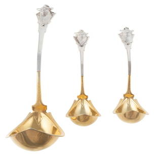
Sold2021Three Rare Coin Silver Ladles by George SharpPhiladelphia, active 1850-1874, retailed by George W Webb; comprising two sauce ladles and a punch ladle, each with a shaped gilt bowl, the terminal with applied bull's head, the underside with monogrSee Sold Price
Sold2021FOUR HENRY MURRAY WATERCOLORSHenry Murray (active 1850-1860), four framed and matted watercolors of fox hunters. 12" x 17.5" ss / 20" x 26" oaSee Sold Price
Sold2021Texas. A very important and rare first state firstTitle: Texas. A very important and rare first state first edition map. 1850 by Thomas. Date/Period: c1850 Size: 16 1/2 x 13 1/2 inches. Material: Hand colored steel engraved Description: A very importSee Sold Price
Sold20241850 ROBERT HORNER MAP OF NEW JERSEY & ADJOINING1850 Robert Horner Revised Map of New Jersey and Adjoining States. Improved from the Thomas Gordon Edition. 34.50" x 57" As isSee Sold Price
Sold2021Hermann Oesterreich (active c. 1850Hermann Oesterreich (active c. 1850), large panorama of Heidelberg with view of castle and Neckar River, oil on canvas, signed lower left, restored-marked, craquelé and paint loss around right andSee Sold Price
Sold2022Antonio Molleno, Santa Rita, ca. 1820Antonio Molleno(Active 1800 - 1850)Santa Rita, ca. 1820hand-adzed wood, gesso, pigmentsWorked between 1800-1850; frequently known as the Chili Painter. In many distinguished permanent collections.9 7/See Sold Price
2 days LeftJasper52Carte de L'Algérie et de la Régence de Tunis' ANDRIVEAU-GOUJON Algeria 1850 map$100
Jun 30Global Auctions CompanyUtagawa Yoshikazu (Japanese, active ca. 1850–70) Japanese Woodblock print$100
Jun 12Dan Morphy AuctionsPLATE CXIII. MAP OF INDIAN TERRITORY SHOWING DISTRIBUTION OF WOODLAND” FROM THE TWENTY-FIRST$100
Jun 11Chiswick AuctionsA mid- 19th century Indian colonial silver curry pan, Calcutta circa 1850 by Lattey Brothers and Co£600
1 day LeftJasper52Map of the World Showing the Geographical Distribution & Range of The Principal Members Of The$45
Featured1 day LeftJasper521640 Blaeu Map of Central France with Clemont-Ferrand as Center -- Auvergne$150
BonhamsMITCHELL (SAMUEL AUGUSTUS) A New Universal Atlas Containing Maps of the Various Empires, Kingdom...£1,300
6 days LeftWorthington GalleriesAntique H/C Map EUROPE SOUS CHARLEMAGNE EN 814: EMPIRES D'OCCIDENT ET D'ORIENT$25
4 days LeftHolabird Western Americana CollectionsSouth & Central America Map Lot c1800's [180163]$100
4 days LeftHolabird Western Americana CollectionsMap of The World in Hemispheres, c1850's [180166]$100
Jun 20The Ross Art GroupOriginal Vintage Chocolat Menier Le Tour de Monde Poster by Jannot 1956 Chocolate Map$500
4 days LeftHolabird Western Americana CollectionsMap of Africa by Edward Weller c. 1800's [180171]$60


![Report on California with maps 1850: Heading: (California & New Mexico) Author: [Taylor, Zachary] Title: California and New Mexico: Message of the President of the United States, Transmitting information... on the Subject of California a](https://p1.liveauctioneers.com/642/197268/99581926_1_x.jpg?height=310&quality=70&version=1615593525)


![Jacob Monk 1853 Map of North America [173506] (1 of 11)](https://p1.liveauctioneers.com/2699/331495/178785775_1_x.jpg?height=282&quality=70&version=1717094933)


![[The Thames] Tombleson (1 of 1)](https://p1.liveauctioneers.com/94/330664/178342457_1_x.jpg?height=282&quality=70&version=1716466933)


![Map of Great Lakes, c1850's [180162] (1 of 1)](https://p1.liveauctioneers.com/2699/331495/178785780_1_x.jpg?height=282&quality=70&version=1717094933)


![South & Central America Map Lot c1800's [180163] (1 of 5)](https://p1.liveauctioneers.com/2699/331495/178785795_1_x.jpg?height=282&quality=70&version=1717094933)
![Map of The World in Hemispheres, c1850's [180166] (1 of 1)](https://p1.liveauctioneers.com/2699/331495/178785785_1_x.jpg?height=282&quality=70&version=1717094933)

![Map of Africa by Edward Weller c. 1800's [180171] (1 of 2)](https://p1.liveauctioneers.com/2699/331495/178785776_1_x.jpg?height=282&quality=70&version=1717094933)