Sold2021Antique Framed Map Livingston,Germantown,Claremont NYAntique Framed Map of Livingston, Germantown and Claremont, Columbia County, NY. Dated 1850. Engraved by R.H.Pease, Albany, NY. Lovely early map is nicely framed in dark brown wood, and wired on the bSee Sold Price
Sold2023City plan of Paris. Jacobs, c.1850Paris France detailed city plan c.1850. Fine large engraved map by Jacobs. Published by Furne in Paris.; Numbered key identifies important buildings and locations. Inset lower left of the environs ofSee Sold Price
Sold20221876 Framed Map1876 Framed Map, "Plan of the City of Philadelphia and Camden", hand colored, entered according to the Act of Congress in the year 1876 by S. Augustus Mitchell in the Office of the Librarian of CongreSee Sold Price
Sold2018Civil War plan of London as fortified by Parliament inTITLE/CONTENT OF MAP: 'A plan of the city and environs of London as fortified by order of Parliament in the years 1642 & 1643' Date: 1776 IMAGE SIZE: Approx 21.5 x 33.5cm, 8.5 x 13.25 inches (Large) TSee Sold Price
Sold20241850 Thomas, Cowperthwait & Co. Map of New York -- City of New-YorkTitle: 1850 Thomas, Cowperthwait & Co. Map of New York -- City of New-York Cartographer: Thomas, Cowperthwait & Co. Year / Place: 1850. Philadelphia Map Dimension (in.): 15.5 X 12. 4 in. This is map oSee Sold Price
Sold20181813 but 1854 Grim's Map of New York CityTitle/Content of Map: 1813 but 1854 Grim's Map of New York City -- A Plan of the City and Environs of New York as they were in the Years 1742, 1743 and 1744 Drawn by D. G. in the 76th Year of his ageSee Sold Price
Sold202319th C Hand Colored Map of State of Maine FRAMEDPublished by S.Augustus Mitchell, Jr. having a published date year of 1860. This hand colored map contains maps of the various countries of the world and plans of cities. Inset at lower right featuresSee Sold Price
Sold2022Plan of the City of Washington, D. C., Mitchell 1861One of the nicer maps of the city, found in S. A. Mitchell, Jr’s 1865 edition of his New General Atlas. This map is a relic of the Civil War, as it was published in the last year of the war. BeaSee Sold Price
Sold20241777 map of Philadelphia "A Plan of the City and Environs of Philadelphia, Engraved and Published by1777 map of Philadelphia "A Plan of the City and Environs of Philadelphia, Engraved and Published by Matthew Albert Lotter 1777". Signed in pencil "Scull and Heap" SCULL, Nicholas; and George HEAP. ExSee Sold Price
Sold2022SOCIETY FOR THE DIFFUSION OF USEFUL KNOWLEDGE The Complete Atlas of Modern, Classical and Celest...SOCIETY FOR THE DIFFUSION OF USEFUL KNOWLEDGE The Complete Atlas of Modern, Classical and Celestial Maps, together with Plans of the Principal Cities of the World, bound in 2 vol., 226 hand-colouredSee Sold Price
Sold2021Mitchells New Universal AtlasDated 1850. 14.5 x 17.5. 129 maps, plans, and sections.See Sold Price
Sold2017Harrison: Antique Map Plan of London, 1776Title/Content of Map: 'A new and complete plan of London, Westminster and Southwark, with the additional buildings to the year 1777' Date Printed: 1776 Image Size: Approx 29.5 x 51.0cm, 11.5 x 20 inchSee Sold Price
Sold2022MITCHELL, SAMUEL AUGUSTUS. A New Universal Atlas Containing Maps of the Various Empires, Kingdoms,MITCHELL, SAMUEL AUGUSTUS. A New Universal Atlas Containing Maps of the Various Empires, Kingdoms, States and Republics of the World; With a Special Map of Each of the United States, Plans of Cities,See Sold Price
Sold2021MITCHELL - New General Atlas [35 American maps] 1867MITCHELL, S. Augustus, Jr.. Mitchell's New General Atlas, containing maps of various countries of the world, plans of cities, etc., ... together with valuable statistical tables. Philadelphia: S. AuguSee Sold Price
Sold2023Pierre Charles L'Enfant Plan of the City of Washington Map18th century. Appx. 13" x 16" overall. Lightly mounted to acid free board with small margin tears and chips.See Sold Price
2023CHRISTO - "LOWER MANHATTAN WRAPPED BUILDING" - Signed litograph with collageCHRISTO (VLADIMIROV JAVACHEFF) (B. 1935)"LOWER MANHATTAN WRAPPED BUILDING, PROJECT FOR 2 BROADWAY, 20 EXCHANGE PLACE"Year: 1991Colour lithograph with collage (fabric, thread, city map, adhesive tape)See Sold Price
Sold2022SPEED, JOHN. The Kingdome of Persia.SPEED, JOHN. The Kingdome of Persia. Hand-colored double-page engraved map of modern-day Iran, Pakistan, and Afghanistan with carte-a-figures and city plan border panels. 16½x21¼ inches sheeSee Sold Price
Sold202119th Century Map of MemphisPLAN DE LA VILLE DE MEMPHIS (ETATS-UNIS) 40,000 HABITANTS pen and ink with watercolor hand drawn drainage system map, circa 1870. Depicts a grid street plan of the city of Memphis with labeled streetSee Sold Price
Sold2022(NEW ORLEANS.) Department of Installation. The World's Industrial and Cotton Centennial(NEW ORLEANS.) Department of Installation. The World's Industrial and Cotton Centennial Exposition... Plan No. 2 Map of the City of New Orleans Showing Location of Exposition Grounds. Large lithographSee Sold Price
Sold2018AN ENAMELLED PORCELAIN 'QUAILS AND MAGPIES' BOTTLEAN ENAMELLED PORCELAIN 'QUAILS AND MAGPIES' SNUFF BOTTLE Porcelain painted in fine polychrome enamels with intensive colors, in slight relief. China, 1770-1850, Qianlong four-character script mark paiSee Sold Price
Sold2022Hill & Wall Aquatint of New York from Governor's IslandHILL, John (1770-1850), After William G. WALL (1792-1864). New York, from Governors Island / No. 20 of the Hudson River Port Folio. Aquatint engraving with original hand color. New York: Henry I. MegaSee Sold Price
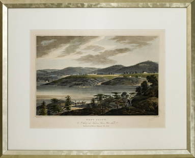
Sold2021After William Guy Wall 'West Point' AquatintAfter William Guy Wall (American 1770-1850) 'West Point', number 16 of the 'Hudson River Port Folio', aquatint on paper after the original from 1825. Sight 24" H x 17.5" W. Frame 28" H x 34" W.See Sold Price
Sold2022Hill & Hornor Aquatint View of Broadway, NYHILL, John (1770-1850), After Thomas HORNOR (1785-1844). Broadway, New-York, Showing Each Building from the Hygeian Depot Corner of Canal Street Niblo's Garden. Aquatint engraving with original hand cSee Sold Price
Sold2018[ATLASES].* [ATLASES]. Four editions of Mitchell's New General Atlas, Containing Maps of the Various Countries of the World, Plans of Cities, Etc. Philadelphia: S. Augustus Mitchell, Jr., 1861 - 1864 - 1878 - 1See Sold Price
2 days LeftJasper521748 Version of Evelyn and Wren Plans for London's Reconstruction -- A Plan of London [on Sheet$95
BonhamsBLAEU (JAN) Delfi Batavorum vernacule Delft, [Amsterdam, 1649 or later]; BLAEU (WILLEM) Novus X...£10
3 days LeftFreeman's | HindmanSTEVENSON, Robert Louis (1850-1894). Kidnapped: Being Memoirs of the Adventures of David Belfour in$250
4 days LeftFreeman's | Hindman[MAP]. SARTINE, Antoine Plan de la Barre et du Havre de Charles-Town...1778. RARE REVOLUTIONARY WAR$1,000(1 bid)
BonhamsCHINA - FIRST OPIUM WAR Military Sketch of the Operations against the City of Chin-Keang on the ...£300
3 days LeftMynt Auctions1850 Half Cent Nice XF Details Key Date C-1 R.2 Nice Eye Appeal Nice Strike$400
Jun 15Riverfront Auctions'1785 Bocage Map of the City of Athens in Ancient Greece' Par M. Barbié du Bocage$5(1 bid)
3 days LeftJasper52COLONIAL GABON & CONGO. Afrique équatoriale française. Brazzaville plan 1929 map$20
4 days LeftHolabird Western Americana CollectionsMaps of San Francisco Bay 1851, 1859 (3) [180180]$150


![MITCHELL - New General Atlas [35 American maps] 1867: MITCHELL, S. Augustus, Jr.. Mitchell's New General Atlas, containing maps of various countries of the world, plans of cities, etc., ... together with valuable statistical tables. Philadelphia: S. Augu](https://p1.liveauctioneers.com/7533/208644/106251073_1_x.jpg?height=310&quality=70&version=1624641782)


![[ATLASES].: * [ATLASES]. Four editions of Mitchell's New General Atlas, Containing Maps of the Various Countries of the World, Plans of Cities, Etc. Philadelphia: S. Augustus Mitchell, Jr., 1861 - 1864 - 1878 - 1](https://p1.liveauctioneers.com/197/119933/61100820_1_x.jpg?height=310&quality=70&version=1522758048)


![BLAEU (JAN) Delfi Batavorum vernacule Delft, [Amsterdam, 1649 or later]; BLAEU (WILLEM) Novus X... (1 of 9)](https://p1.liveauctioneers.com/1043/319451/178359083_1_x.jpg?height=282&quality=70&version=1716978850)


![[MAP]. SARTINE, Antoine Plan de la Barre et du Havre de Charles-Town...1778. RARE REVOLUTIONARY WAR (1 of 1)](https://p1.liveauctioneers.com/197/329395/177650540_1_x.jpg?height=282&quality=70&version=1715364962)


![Maps of San Francisco Bay 1851, 1859 (3) [180180] (1 of 3)](https://p1.liveauctioneers.com/2699/331495/178785789_1_x.jpg?height=282&quality=70&version=1717094933)

