Sold2015Morse's North American AtlasNew York: Harper and Brothers, 1842 (actually 1845), Sabin 50969, with 36 hand-colored maps (complete), bound in leather-backed marbled flexible boards, 17-1/4 x 13-3/4 in., maps have small amounts ofSee Sold Price
Sold2024Tanner's North America independent TexasHeading: (North America) Author: Tanner, Henry Schenck Title: North America Place Published: Philadelphia Publisher: Date Published: 1836-[1845] Description: Engraved map, hand-coloSee Sold Price
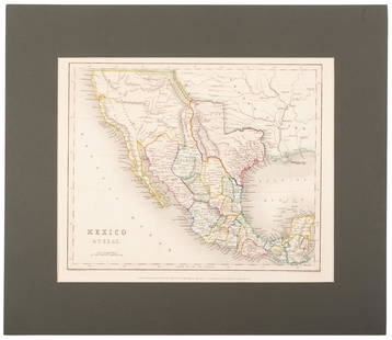
Sold2020Mexico with a large independent Texas, c.1845 mapHeading: Author: Gilbert, James Title: Mexico & Texas Place Published: London Publisher:Grattan & Gilbert Date Published: c.1845 Description: Engraved map, hand-colored in outliSee Sold Price
Sold2020North America with independent TexasHeading: Author: Dufour, Adolphe Hippolyte Title: [Amerique du Nord] Place Published: [Paris] Publisher:Imp. de N. Rémond Date Published: c.1845 Description: Engraved map, hand-See Sold Price
Sold2020Tanner's North America independent TexasHeading: (Texas) Author: Tanner, Henry Schenck Title: North America Place Published: Philadelphia Publisher: Date Published: 1836-[1845] Description: Engraved map, hand-coloSee Sold Price
Sold2023Historical Collections of New York, 1845New York State. - John W. BARBER & Henry HOWE. Historical Collections of the State of New York. New York: 1845. Octavo. 1 folding map (hand-colored I outline), plates, numerous illustrations. (ToningSee Sold Price
Sold2018Levasseur's decorative North AmericaHeading: Author: Levasseur, Victor Title: Amérique Septentrionale Place Published: Paris Publisher:A. Combette Date Published: [c.1845] Description: Steel-engraved map, hanSee Sold Price
Sold2022Early Nineteenth Century Map of Texas.Early 19th century hand colored map of Texas published by C.S. Williams, NE Corner of Market and 7th St., Philadelphia, 1845. Map engraved by J.H. Young exhibits previous folds and has been laid down.See Sold Price
Sold2018Meyer: South Carolina with Charleston InsetReserve Reduced! The beautifully detailed and colored map of South Carolina "with its canals, streets, steamship routes and distances between main towns" from the 1845 edition of Meyer's Hand-Atlas. ISee Sold Price
Sold2020Map of Mexico and Texas c.1845Heading: (Texas) Author: Wyld, James Title: Republic of Mexico and Texas Place Published: London Publisher: Date Published: c.1845 Description: Engraved map, with Mexico portionSee Sold Price
Sold2017History of Wyoming - William Miner 1845History of Wyoming in a Series of Letters from Charles Miner, to His Son William Penn Miner, Esq. Map of Wyoming present. Hand colored. Author: Charles MinSee Sold Price
Sold2020Meyer: Missouri, 1845Description: The beautifully detailed and colored map of Missouri, from Meyer's Hand-Atlas. Includes steamship routes between St. Louis and Shawnee Town, Prairie du Chien, and Kanzas (sic) River. CartSee Sold Price
Sold2023Early C.S. Williams Map Of Texas1845, Map Of Texas From The Most Recent Authorities, Hand Colored Engraving, Sight 12 X 15 Inches, Matted And Burl Frame 22 X 25 X 0.5 Inches, Slight Toning To Paper Appropriate For Age, Not ExaminedSee Sold Price
Sold2022Map of North America with Independent TexasSteel-engraved map of North America with Texas shown as an independent country, hand-colored in outline. Published by T. Tegg, London, circa 1845. [10" H x 8 1/2" W]. Slightly toned, near fine.See Sold Price
Sold2018Meyer: Antique Map of Pennsylvania, 1845Neueste Karte von Pennsylvania The beautifully detailed and colored map of Pennyslvania "with its canals, railroads, etc.," from the 1856 edition of Meyer's Hand-Atlas. Includes a profile of PennsylvaSee Sold Price
Sold2016ANTIQUE NEW-FRANCE HAND COLORED MAPANTIQUE NEW-FRANCE HAND COLORED MAP, H 27 1/2" IMAGE, W 20 1/2":Framed, measures H.30" x 23" overall.See Sold Price
Sold2024Matthaus Merian 1627 Antique Hand Colored Map "Virginia" from Theodore de Bry's "Grand Voyages" #2Antique 1627 hand-colored map of Virginia by Matthaus Merian after John Smith's 1612 map, from Theodore de Bry's "Grand Voyages". Good condition overall, with age-appropriate wear, repairs (see photosSee Sold Price
Sold20161666 Original Hand Colored Map of Virginiaapprox 21" X 17"...... Pas Caerte van Nieu Nederlandt en de Engelsche Virginies, van Cabo Cod tot Cabo Canrick. (Chart of New Netherland and the English Virginias from Cape Cod to Cape Canrick [i.e. HSee Sold Price
Sold2024Henricus Hondius 1630 "Nova Virginiae Tabula" Hand Colored Map of Virginia and Chesapeake #1Antique, original hand-colored map of Virginia and the Chesapeake Bay originally by Henricus Hondius in 1630 titled "Nova Virginiae Tabula". With French text on reverse final catchword "n'en" and signSee Sold Price
Sold2024John Speed 1676 Antique Hand Colored "Map of Virginia and Maryland" #2Antique 1676 hand-colored map of Virginia and Maryland engraved by Francis Lamb and republished by Thomas Basset & Richard Chriswell after John Speed's 1611 atlas. Good overall, apparent repairs, minoSee Sold Price
Sold2020F. B. Werner, "Roma" hand-colored map, 1730F. B. Werner, "Roma" hand-colored map, 1730, Panoramic view of Rome, hand-colored engraving on laid paper, no watermark observed, two sheets joined at center, marked "F. B. Werner delin Ao 1730" and "See Sold Price
Sold2024Very Rare Mexico Nova Hispania 1579 Hand Colored MapORTELIUS, Abraham (1527-1598). Theatrum Orbis Terrarum. 1570. It is considered to be the first modern atlas. Map of New Spain (Mexico), 1579. Printed in Antwerp by Christophe Plantin (1588). Etching.See Sold Price
Sold2021Hand colored map, Africa. 23” x 20.5”Hand colored map, Africa. 23” x 20.5”See Sold Price
Sold2020Small Hand-Colored Map of Nantucket by William SchontzeSmall Hand-Colored Map of Nantucket by William Schontzeler,rare pictorial map of Nantucket in original frame, signed, l.r William Cotton Schontzeler, trained as a draftsman in NY, he owned and workedSee Sold Price
18 mins LeftAlbion AuctionsMarmocchi, F. C. 1845 Hand Col Map. Judaica - Jewish World & Israelites Camp$5
18 mins LeftAlbion AuctionsMarmocchi, F. C. 1845 Hand Col Map. Arabia, Syria, Cyprus, Crete, Egypt$15(2 bids)
18 mins LeftAlbion AuctionsMarmocchi, F. C. 1845 Hand Col Map. Greek Colonies. Ancient Greece$5(1 bid)
18 mins LeftAlbion AuctionsMarmocchi, F. C. 1845 Hand Col Map. Holy Land. Persia Empire, Alexander the Great$5(1 bid)
18 mins LeftAlbion AuctionsMarmocchi, F. C. 1845 Hand Col Map. Egypt Pharaoh Empire, David Salomon$5(1 bid)
18 mins LeftAlbion AuctionsMarmocchi, F. C. 1845 Hand Col Map. Holy Land. Canaan. Israel Palestine$5(1 bid)
18 mins LeftAlbion AuctionsMarmocchi, F. C. 1845 Hand Col Map. Holy Land. Israel, Jerusalem inset$5(1 bid)
18 mins LeftAlbion AuctionsMarmocchi, F. C. 1845 Hand Col Map. Black Sea. Greece Armenia Turkey Russia$5
May 26Ararity AuctionsThomson's 1817 Hand Colored Map Comparative Heights of the World's Great Mountains$50
18 mins LeftAlbion AuctionsPrichard & Walker 1844 Hand Colored Map. Ethnological Map of Asia$15(2 bids)
5 days LeftThomaston Place Auction GalleriesHAND COLORED MAP OF PERU & COUNTRY OF THE AMAZONS, 1747, BY EMANUEL BOWEN, FRAMED$250
1 day LeftBlackstone Valley Auctions & Estates LLCRevolutionary Era War Map of the Attack on Ft. Moultrie.$275(3 bids)


![Tanner's North America independent Texas: Heading: (North America) Author: Tanner, Henry Schenck Title: North America Place Published: Philadelphia Publisher: Date Published: 1836-[1845] Description: Engraved map, hand-colo](https://p1.liveauctioneers.com/642/319971/171838592_1_x.jpg?height=310&quality=70&version=1708136548)
![North America with independent Texas: Heading: Author: Dufour, Adolphe Hippolyte Title: [Amerique du Nord] Place Published: [Paris] Publisher:Imp. de N. Rémond Date Published: c.1845 Description: Engraved map, hand-](https://p1.liveauctioneers.com/642/174090/87617771_1_x.jpg?height=310&quality=70&version=1595023143)
![Tanner's North America independent Texas: Heading: (Texas) Author: Tanner, Henry Schenck Title: North America Place Published: Philadelphia Publisher: Date Published: 1836-[1845] Description: Engraved map, hand-colo](https://p1.liveauctioneers.com/642/171046/86179542_1_x.jpg?height=310&quality=70&version=1591835061)

![Levasseur's decorative North America: Heading: Author: Levasseur, Victor Title: Amérique Septentrionale Place Published: Paris Publisher:A. Combette Date Published: [c.1845] Description: Steel-engraved map, han](https://p1.liveauctioneers.com/642/127929/65081039_1_x.jpg?height=310&quality=70&version=1537227236)


![Map of North America with Independent Texas: Steel-engraved map of North America with Texas shown as an independent country, hand-colored in outline. Published by T. Tegg, London, circa 1845. [10" H x 8 1/2" W]. Slightly toned, near fine.](https://p1.liveauctioneers.com/1221/243451/126278661_1_x.jpg?height=310&quality=70&version=1649868014)


