Sold20201844 Map of New ZealandAuthor: Hughes Title: 1844 Map of New Zealand Materials: Ink on Paper Dimensions: 12.5"X17" Description: Map date 1844. Drawn by W. Hughes. Published by A. C. Black in London and then Edinburgh. ThisSee Sold Price
Sold20211844 map of the U. S., Canada & MexicoGreat map of the United States showing Texas in a very large configuration, otherwise known as the “Stovepipe” shape, with its northern border going all the way into what would become the state ofSee Sold Price
Sold2021Scarce 1844 map of N. America, OlneyElusive and interesting map of North America from Olney’s 1844 School Geography. Texas Territory is shown in the year just before gaining statehood. Although it shows borders consistent with the TexSee Sold Price
Sold2024PATAGONIA. Argentina Chile Tierra del Fuego Falklands S Georgia.SDUK 1844 mapCAPTION PRINTED BELOW PICTURE: 'SOUTH AMERICA, SHEET V., PATAGONIA; inset South Georgia, South Shetlands and Orkneys' DATE PRINTED: This map was originally published by The Society for the Diffusion oSee Sold Price
Sold2024OTTOMAN EMPIRE in Europe & Asia. Greece. British Ionian Islands. SDUK 1844 mapTITLE/CONTENT OF MAP: 'TURKISH EMPIRE IN EUROPE AND ASIA WITH THE KINGDOM OF GREECE' Coloured in pink are the United States of the Ionian Islands as a separate entity from Greece and Turkey, a state aSee Sold Price
Sold2023SOUTH AMERICA Brazil Chile Peru Bolivia Patagonia La Plata Ecuador SDUK 1844 mapTitle: SOUTH AMERICA Brazil Chile Peru Bolivia Patagonia La Plata Ecuador SDUK 1844 map Description: SOUTH AMERICA' by Engraved by J & C Walker (This map was originally published by The Society for thSee Sold Price
Sold2023SOUTH AMERICA Brazil Chile Peru Patagonia La Plata Bolivia Litoral SDUK 1844 mapTitle: SOUTH AMERICA Brazil Chile Peru Patagonia La Plata Bolivia Litoral SDUK 1844 map Description: SOUTH AMERICA' by Engraved by J & C Walker (This map was originally published by The Society for thSee Sold Price
Sold2023OTTOMAN EMPIRE in Europe & Asia. Greece. British Ionian Islands. SDUK 1844 mapTITLE/CONTENT OF MAP: 'TURKISH EMPIRE IN EUROPE AND ASIA WITH THE KINGDOM OF GREECE' Coloured in pink are the United States of the Ionian Islands as a separate entity from Greece and Turkey, a state aSee Sold Price
Sold20241844 Map of the Southern States by Jesse Olney“Map of Part of the Southern States to Illustrate Olney’s School Geography” published 1844 by Jesse Olney. Shows early railway routes. Six states shown. Archival tape repair to upperSee Sold Price
Sold20201844 Map of FrankfurtAuthor: Clarke Title: 1844 Map of Frankfurt Medium: Ink on Paper Dimensions: 17"X14.5" Description: Map of the city of Frankfurt dated 1844. Drawn by W.B. Clarke and engraved by T.E. Nicholson. PublisSee Sold Price
Sold2023SOUTH BRAZIL with PARAGUAY & URUGUAY. Bahia Minas Gerais Sao Paolo SDUK 1844 mapTitle: SOUTH BRAZIL with PARAGUAY & URUGUAY. Bahia Minas Gerais Sao Paolo SDUK 1844 map Description: SOUTH AMERICA, SHEET III., SOUTH BRAZIL WITH PARAGUAY AND URUGUAY' by Cartography by Spix & MartiusSee Sold Price
Sold2024OTTOMAN EMPIRE in Europe & Asia. Greece. British Ionian Islands. SDUK 1844 mapTITLE/CONTENT OF MAP: 'TURKISH EMPIRE IN EUROPE AND ASIA WITH THE KINGDOM OF GREECE' Coloured in pink are the United States of the Ionian Islands as a separate entity from Greece and Turkey, a state aSee Sold Price
Sold2023BUKHARA KABUL & BALUCHISTAN.Afghanistan Khorassan Sinde Pakistan SDUK 1844 mapBOKHARA, CABOOL AND BELOOCHISTAN.' by Engraved by J & C Walker (This map was originally published by The Society for the Diffusion of Useful Knowledge in 1838; this date is printed on the map. This edSee Sold Price
Sold2024CENTRAL ASIA.Western Siberia, Khiva Bukhara. Independent Tartary.SDUK 1844 mapCAPTION PRINTED BELOW PICTURE: 'WESTERN SIBERIA, Khiva and Bokhara' DATE PRINTED: This map was originally published by The Society for the Diffusion of Useful Knowledge in 1838; this date is printed oSee Sold Price
Sold20201844 MAP AFRICA1844 MAP AFRICA, color, marked 7ink 1844pencil ; approx measure. 16in x 13.5 color atlas folded showing AFRICA lower mediterranean Europe southwest part of asia minor, folded, printed at bottom; PubliSee Sold Price
Sold20201844 MAP AFRICA1844 MAP AFRICA, color, marked 7ink 1844pencil ; approx measure. 16in x 13.5 color atlas folded showing AFRICA lower mediterranean Europe southwest part of asia minor, folded, printed at bottom; PubliSee Sold Price
Sold2023Reclus, Elisee C1880 Antique Map. Edinburgh and the Firth of Forth ScotlandLithograph Map Published 1876-94, London for "The Universal Geography" by Elisee Reclus. Edited by A. H. Keane. Reverse side blank. Centre fold as published. Paper Size: 13 x 10.5 inch (33 x 27cm) GooSee Sold Price
Sold2021(4) SCOTTISH VICTORIAN STERLING SILVER TEA SERVICE(lot of 4) Scottish Victorian sterling silver tea service, Leonard Urquhart, c.1843-1844, Edinburgh hallmarks, in the Rococo taste, with acanthus scroll handles, repousse trailing flowers, including:See Sold Price
Sold2017South America Map, 1844South America, Sheet I., Ecuador, New Granada, Venezuela And Parts Of Brazil And Guyana, 1844 Map. This map was originally published by The Society for the Diffusion of Useful Knowledge in 1842; thisSee Sold Price
Sold2021Atlases - Black, A. & C.: Publisher Black's GeneralAtlases - Black, A. & C.: Publisher Black's General Atlas comprising sixty one maps. Edinburgh, 1850. Folio, 61 maps partly coloured, maroon half morocco, rubbed; Hall, Sydney Black's General Atlas...See Sold Price
Sold20201638 Hondius Map of Edinburgh Environs in Scotland -- ATitle/Content of Map: 1638 Hondius Map of Edinburgh Environs in Scotland -- A New Description of the Shyres Lothian and Linlitquo. Be T. Pont. Date: 1638, Amsterdam Cartographer: Hondius [family] SizeSee Sold Price
Sold20201844 Boynton Map of Boston -- Plan of the City ofTitle/Content of Map: 1844 Boynton Map of Boston -- Plan of the City of Boston… Cartographer: G Boynton Year/Place: 1844, Boston Size: 9.6 X 11.2 in. This is an impressive striking plan of Boston feSee Sold Price
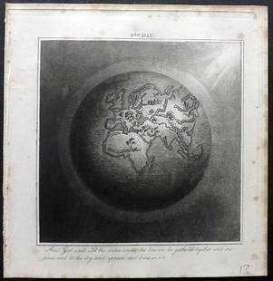
Sold2019Rhind, William 1844 Rare Map of the Old World. EarthAquatint Map Published 1844, London "The Creation: Illustrated By Six Engravings On Steel" by William Graeme Rhind. Rare. Paper Size: 6.5 x 6 inch (16.5 x 16cm) Very minor margin toning, slightly affeSee Sold Price
Sold20201844 Tanner Map of Maryland and Delaware -- A New MapTitle: 1844 Tanner Map of Maryland and Delaware -- A New Map of Maryland and Delaware with their Canals, Roads & Distances Cartographer: H Tanner Year/Place: 1844, Philadelphia Size: 10.9 X 14.3 in. DSee Sold Price
Featured17 hrs LeftJasper52SOUTHERN MEXICO & CENTRAL AMERICA. Yucatan Belize Mosquito Coast.SDUK 1844 map$35
17 hrs LeftJasper52BOLIVIA, PERU with part of Brazil. Indian tribes Bolivian Litoral SDUK 1844 map$10
17 hrs LeftJasper52SOUTH AMERICA.La Plata and Chilé.Chile Argentina Uruguay Bolivia.SDUK 1844 map$40
17 hrs LeftJasper52AMAZONIA.Showing "El Dorado?", missions & tribes. Brazil Ecuador.SDUK 1844 map$130
Featured17 hrs LeftJasper52SOUTH AMERICA. Brazil Chile Peru Bolivia Patagonia La Plata. SDUK 1844 old map$100
10 hrs LeftRapid Estate Liquidators and Auction Gallery1844 "Chambers's Edinburgh Journal, Volume 1"$30


![1638 Hondius Map of Edinburgh Environs in Scotland -- A: Title/Content of Map: 1638 Hondius Map of Edinburgh Environs in Scotland -- A New Description of the Shyres Lothian and Linlitquo. Be T. Pont. Date: 1638, Amsterdam Cartographer: Hondius [family] Size](https://p1.liveauctioneers.com/5584/158575/80095691_1_x.jpg?height=310&quality=70&version=1578446373)