Sold20191835 Hammond World Map -- The WorldTitle/Content of Map: 1835 Hammond World Map -- The World Cartographer: J Hammond Size: 11 x 17 in. A nice world map showing the Eastern and Western Hemispheres as well as polar projections and climatSee Sold Price
Sold2018Vintage Hammond World Map, 1950Hammond World Map Circa 1950 Approx. 33x49 inches. Folded size approx. 8+x12+ inches, 16-fold. No Reserve: This lot starts at $1 and has no reserve as a courtesy so that collectorSee Sold Price
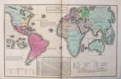
Sold20211835 Smith World Map -- A Chart Exhibiting the ActualTitle: 1835 Smith World Map -- A Chart Exhibiting the Actual and Comparative Size of each Country, Nation, or Kingdom; its Population as a Whole and to a Square Mile. Also the Different States of SociSee Sold Price
Sold20171933 Small Hammond World Atlas; Maps & Statistics1933 Small Format Hammond World Atlas; numerous color Maps & Statistics. Black leather cover inset with with a Chinese Cinnabar Red lacquer plaque; interesting end papers. Spine missing, covers loose,See Sold Price
Sold2017Smith: Antique Map of the World, 1835Map: 1835 Smith World Map -- A Chart Exhibiting the Actual and Comparative Size of each Country, Nation, or Kingdom; its Population as a Whole and to a Square Mile. Also the Different States of SocietSee Sold Price
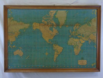
Sold2022C. S. Hammond & Co. NY Framed World MapC. S. Hammond & Co. NY Framed World Map. 24 1/2" X 20 1/2"See Sold Price
Sold2016Vintage Hammond's International Map of WorldVintage Hammond's International Map of the World. Prepared for the World Book Encyclopedia. 35" H x 51" W.See Sold Price
Sold2022Hammond Ambassador World Atlas, Gazetteer, 1stEd. 1957, Maps"Hammond's Ambassador World Atlas and Gazetteer?, published by C.S. Hammond, Maplewood, New Jersey, First Edition, Fifth Printing January 1957 [1st printing was issued July 1954] Hard boards, originalSee Sold Price
Sold2016Map of known world of the ancients. 1835.Print of hand colored steel engraving titled „Monde connu des Anciens“.Author C. V. Monin.Engraved by unknown.From the „Atlas Universel de Geography“ by C. V. Monin. Parsi. 1835.See Sold Price
Sold2020VINTAGE CANADIAN CLUB WHISKEY ADVERTISEMENT on HAMMONDsVINTAGE CANADIAN CLUB WHISKEY ADVERTISEMENT on HAMMONDs INT'L MAP of the WORLD Vintage CANADIAN CLUB WHISKY Advertisement on HAMMOND'S INTERNATIONAL MAP OF THE WORLD. Printed advertisement text in comSee Sold Price
Sold202117 World Atlas's And MapsIncludes Look At The World, Rand McNally World Atlas, Morton's Elementary Geography, The New World Atlas & Gazetteer, Collier's World Atlas & Gazetteer, Hammond's New Era Atlas Of The World, Planet EaSee Sold Price
Sold2023HAMMONDS SELF REVISING WORLD ATLAS AND GAZETTEER - 47 PAGESDescription: HAMMONDS SELF REVISING WORLD ATLAS AND GAZETTER - 47 PAGES. It contains latest colored maps of the world Gazetteer, pictures, flags and complete index. Material: PaperSee Sold Price
Sold2021Atq Map & Atlas Books, 1899 Spoffords & More - 1899Atq Map & Atlas Books, 1899 Spoffords & More - 1899 Maps Spofford's Cabinet Encyclopedia, 1906 Hammonds Pictorial Atlas of World w/ 1956 Hammond Double Day AtlasSee Sold Price
Sold2021MAP, North America, LevasseurNorth America. Victor Levasseur, Amerique Septentrionale, from Atlas Universel Illustre, 1835 (circa). Hand Color. This early version of Levasseur's decorative map of North America shows Mexico in conSee Sold Price
Sold20201917 Map of CubaTitle: 1917 Map of Cuba Medium: Ink on Paper Dimensions: 8"X6" Map of the island of Cuba dated 1917. Published by Hammond and co in New York. Part of the Handy Atlas of the World. Color coded for terrSee Sold Price
Sold2016T-O World Map.- Lucanus (Marcus Annaeus) Pharsalia,Lucanus (Marcus Annaeus) Pharsalia, manuscript on paper, [Northern Italy (possibly Padua), first half of the fifteenth century]. 294 x 217mm., I + 149 + I leaves (including defective leaves and 3 blanSee Sold Price
Sold2024Petrus Plancius, Engraved World MapOrbis Terrarum Typus de Integro Multis in Locis Emendatus. Petrus Plancius (1552-1622). Copper-plate engraving with original hand color in full. Amsterdam, 1594. Some stains, creases, folds. Sight sizSee Sold Price
2022Blaeu, Johannes (Netherlands, 1596-1673) "The New World Map" Double Hemisphere World Map C. 1664Nova et Accuratissima Totius Terrarum Orbis Tabula Translated "The New World Map", Hand Colored w/ Elaborately Decorated Spandrels.   Sight View 16" x 21-1/2", Overall View 21" x 25-1/2"See Sold Price
Sold2018Ortelius' 1570 world mapHeading: Author: Ortelius, Abraham Title: Typus Orbis Terrarum Place Published: Antwerp Publisher: Date Published: 1570-[1584?] Description: Copper-engraved map, hand-colorSee Sold Price
2018Important World Map from the Nuremberg Chronicle, 1493Title/Content of Map: World Map from the Nuremberg Chronicle. One of the most important world Maps ever produced Date Printed: 1493 Cartographer: Hartmann Schedel Material/Medium: Paper Size: 18" x 25See Sold Price
Sold2023A Witco Tiki Art World MapWorld Map mixed media sculpture mid century modern Witco 37.25 x 62.25 inches Overall very good condition.See Sold Price
Sold2017World mapWorld map 'Nova Totius Terraum Orbis Geographica Ac Hydrographica Tabula', copper engraving map of Heinrich Hondius, dated 1630,two hemispheres the world map, surrounded by rich allegorical representaSee Sold Price
Sold2020Mercator World Map*** START PRICE IS THE RESERVE *** [World] MERCATOR, Rumold (1545-1599). Orbis Terrae Compendiosa Descriptio Quam ex Magna Universali Mercatoris... Engraved Map with original hand color. Geneva, 1587.See Sold Price
Sold2022Massive World Map Custom-Made Coffee Table 1995One of a kind, all iron and custom glass work, signed in 1995. Aprox. Weight: 200 lbs -Measurements: 65 in L x 40 in x 23 in HSee Sold Price
BonhamsBRADFORD (THOMAS G.) A Comprehensive Atlas, Geographical, Historical & Commercial, 1835; and atl...£500
4 days LeftJasper521833 Woodbridge World Map -- Map of the World Adapted to Woodbridge's Geography$40
Jun 09Worthington Galleries19th c. Hemisphere World Map, Hohen und Tiefen der Erde in Lambert’s Zenithal-Projection von$10
4 days LeftJasper521881 Vuillemin World Map with French Colonies Shown -- Planisphere: Indiquant les Colonies Francises$30
13 hrs LeftRapid Estate Liquidators and Auction GalleryVintage Cricket Gillette World Map Lighter Holder$10
Jun 15Fine Arts OutletYoung Couple Reviewing a World Map Bronze Statue - Size: 32"L x 47"W x 42"H.$3,150
Jun 09Worthington Galleries18th c. Map OBSERVATIONS SUR LES POINTS CARDINAUX. LIGNES, ET CIRCLES DE LA SPHÈ$10


![Hammond Ambassador World Atlas, Gazetteer, 1stEd. 1957, Maps: "Hammond's Ambassador World Atlas and Gazetteer?, published by C.S. Hammond, Maplewood, New Jersey, First Edition, Fifth Printing January 1957 [1st printing was issued July 1954] Hard boards, original](https://p1.liveauctioneers.com/6304/266436/140047426_1_x.jpg?height=310&quality=70&version=1668866616)


![T-O World Map.- Lucanus (Marcus Annaeus) Pharsalia,: Lucanus (Marcus Annaeus) Pharsalia, manuscript on paper, [Northern Italy (possibly Padua), first half of the fifteenth century]. 294 x 217mm., I + 149 + I leaves (including defective leaves and 3 blan](https://p1.liveauctioneers.com/5458/94966/48431616_1_x.jpg?height=310&quality=70&version=1476369049)


![Ortelius' 1570 world map: Heading: Author: Ortelius, Abraham Title: Typus Orbis Terrarum Place Published: Antwerp Publisher: Date Published: 1570-[1584?] Description: Copper-engraved map, hand-color](https://p1.liveauctioneers.com/642/127929/65081054_1_x.jpg?height=310&quality=70&version=1537227236)


![Mercator World Map: *** START PRICE IS THE RESERVE *** [World] MERCATOR, Rumold (1545-1599). Orbis Terrae Compendiosa Descriptio Quam ex Magna Universali Mercatoris... Engraved Map with original hand color. Geneva, 1587.](https://p1.liveauctioneers.com/1968/163248/82424686_1_x.jpg?height=310&quality=70&version=1583340284)


