Sold2015Jansson (Jan) - [Atlas Novus: Germany],single vol. lacking title, 106 mostly regional maps of Germany and northern Europe, but also including a general map of Germany, and classical maps of both Germany and Scandinavia, and several city plSee Sold Price
Sold20211861 Map of GermanyAuthor: Johnson Title: 1861 Map of Germany Medium: Ink on Paper Dimensions: 18"X13.5" Map of Germany dated 1861. Engraved by A.J. Johnson dated 1861. Published by Johnson and Ward in New York. CaptureSee Sold Price
Sold2022(MISCELLANEOUS MAPS.) Group of 18 double-page or folding engraved European regional maps.(MISCELLANEOUS MAPS.) Group of 18 double-page or folding engraved European regional maps. Folio sheets; European makers. 17th-18th centuries - Eugene Henry Fricx. Les Costes du Boulenois, et le pas deSee Sold Price
Sold2024Three Antique Regional MapsThree Antique Regional Maps all copperplate engravings to include: Calabre (Paris: N.S. d'Abbeville, 1648), with handcolor, depicting Calabria and northeastern Sicily (overall sheet 18 x 23-3/4 in.) (See Sold Price
Sold2022Times Atlas 1895 Mixed Lot of 18 MapsIncl Germany, Holland, Denmark, Ireland, Bohemia, Atlantic, Belgium/Luxemburg, Alps, Hungary, Mediterranean, Caucasus, Norway/Sweden, Southern Sandinavia etc. Lithograph Map Published 1895, London forSee Sold Price
Sold2023Set 4 19th Century Johnson & Ward Color Maps Germany Mexico Switzerland & Central AmericaSet 4 19th Century Johnson & Ward Color Maps Germany Mexico Switzerland & Central America. Measurements in inches: 18 x 14 Condition:Has toning and tear to edges Shipping:We offer in-house shipping. ISee Sold Price
Sold20212 Pyrography Leather MapsTwo Pyrography Leather Maps, in scroll form with wood rod ends, both with pyrography and polychromed designs, includes: world and regional maps, early 20th C, 21" x 16", 21" x 18". CONDITION: Modest wSee Sold Price
Sold2019Germany (1) north and east.Title/Content of Map: Germany (1) north and east. Date: 1863 Cartographer: By Johnson & Ward. From, Johnson’s New Illustrated Family Atlas Size: 18 x 13 3/4” Provenance: New York Additional Info:See Sold Price
Sold2021Stieler, Adolph 1905 Lot 7 Maps Austria Germany HungaryLithograph Maps Published 1905 by Justus Perthes, Gotha for "Stielers Hand-Atlas" by Adolf Stieler. Centre fold as published. Paper Size: 18.5 x 15.5 inch (48 x 40cm) One map split in two. OccasionalSee Sold Price
Sold2021Mid Century 2-Tier Brass, Tile & Glass Bar CartBrass frame with "C" side supports, top tier having hand painted tiles depicting a map of Germany, lower tier with black glass insert; 31 1/4" x 18 1/4", 26 1/2"H; one tile with repair, tarnish to fraSee Sold Price
Sold2023Baedeker, Karl 1900 Lot of 94 Maps of Northern Germany & AustriaLithograph Maps Published 1900, Leipzig for "Northern Germany as far as the Bavarian and Austrian Frontiers" by Karl Baedeker. Folds as issued. Paper Size: Up to 18 x 12 inch (46 x 30cm) Good ConditioSee Sold Price
Sold2022Stieler, Adolf 1874 Lot of 4 Maps of Russia & GermanySteel Engraved Maps with outline hand colour Published 1874, Gotha, Germany for "Hand-Atlas über alle Theile der Erde und über das Weltgebäude" by Adolf Stieler. Paper Size: 18.5 x 14.5 inch (47 xSee Sold Price
Sold2024Johann Baptist Homann Kingdom of Denmark MapJohann Baptist Homann Germany 1664-1724 Map of Denmark and the territories within the Danish Kingdom by German cartographer Johann Homann. Etching on paper,Image area 18 1/2" x 22".Frame 22 1/4" x 25See Sold Price
Sold2019Paris (France)Title: Paris (France) Publication Date: 1896 Cartographer: CRAM, GEORGE F. Publisher: GEORGE F. CRAM Size: 12 X 18.5 Highly detailed double page map. On reverse, plans of Berlin, Germany and Calcutta,See Sold Price
Sold2019Gibson & Salmon 1759 Map of the South Part of GermanyCopper Engraved Map Published 1759, London for "The Universal Traveller" by Thomas Salmon. Engraved by Gibson. Paper Size: 18.5 x 13.5 inch (47 x 34cm) Some toning along centre fold, some strengtheninSee Sold Price
Sold201918) VINTAGE GERMAN LANGUAGE BADEKERS TRAVEL GUIDES(lot of 18) Badekers German language travel guides, mostly Germany, a few other countries including Russia, Norway and Sweden, India, includes maps, cities, destinations, years include 1893, 1895, 190See Sold Price
Sold2018Lotter: Antique Map of Africa, 1772Title/Content of Map: Africa by Lotter Date Printed: 1772 Cartographer: G.C. Lotter Material/Medium: Paper Size: 23" x 18" Hand colored copperplate engraved. Published in Augsburg Germany. Please noteSee Sold Price
Sold2016Empire of Germany by Johnson 1868Map Title: Empire of Germany Maker: Johnson Date: 1868 Publisher: Alvin J. Johnson & Co.: New York Size: 18 x 26 inches From Johnson's Atlas of the World Map includes vignette of Prussia and details cSee Sold Price
Sold2018Stieler, Adolf 1874 Map of Asia"Asia…" Steel Engraved Map with outline hand colour Published 1874, Gotha, Germany for "Hand-Atlas über alle Theile der Erde und über das Weltgebäude" by Adolf Stieler. Paper Size: 18.5 x 14.5 inSee Sold Price
Sold2018Stieler, Adolf 1874 Map of Africa Continent"Afrika" Steel Engraved Map with outline hand colour Published 1874, Gotha, Germany for "Hand-Atlas über alle Theile der Erde und über das Weltgebäude" by Adolf Stieler. Paper Size: 18.5 x 14.5 incSee Sold Price
Sold2023A RARE 16TH/17TH CENTURY EUROPEAN IRON SECRET STRONG BOX probably Netherlands of Germany. 18 cm x 18A RARE 16TH/17TH CENTURY EUROPEAN IRON SECRET STRONG BOX probably Netherlands of Germany. 18 cm x 18 cm.See Sold Price
Sold2024Keith Haring Artwork Signed on a Shell Oil New York Road Map 18 in. x 24 in.Keith Haring Artwork Signed on a Shell Oil New York Road Map 18 in. x 24 in. size: 18 x 42 open - rippingSee Sold Price
Sold2023Lehmann schaukelnde Puppe 295Tin toy, clockwork drive, function tested, hand-painted, colour red gold, around 1895, Made in Germany, 18 cm, mint condition, anodised, extremely rare, only two copies known to meBlechspielzeug, UhrwSee Sold Price
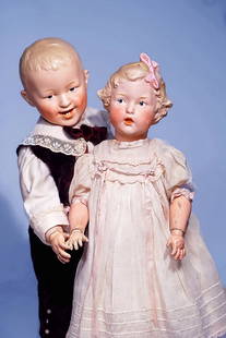
Sold2017205. GERMAN BISQUE CHARACTER, 7764, BY GEBRUDER205. GERMAN BISQUE CHARACTER, 7764, BY GEBRUDER HEUBACH KNOWN AS "SINGING HEUBACH". Marks: 6 Heubach sunburst mark, 7764 Germany. 18". Bisque socket head, sculpted brown tousled curls and modeled largSee Sold Price
4 days LeftJasper521552 Munster Regional German Map Centered on Bamberg -- Franconia XIII Nova Tabula$95
6 days LeftSwann Auction Galleries(IBERIA.) Thomas Lopez. Atlas Geographico del Reyno de Espana, e Islas Adyacentes.$450
Featured4 days LeftJasper521680 Wit Map of Southern Netherlands -- Ducatus Geldriae, et Comitatus Zutphaniae, Tabula...$130
Jun 15Ladenburger Spielzeugauktion GmbHtreasure chest, dollhouse decoration pieces, tin, glass, wood, ceramic, 1 Biedermeier bed, 16 cm,€20
6 days LeftLadenburger Spielzeugauktion GmbHSTEIFF mixed lot of cats, 6 pieces, among it Kitty and Tabby and Tapsy, partially with button,€60(1 bid)
Jun 15Ladenburger Spielzeugauktion GmbHmixed lot of dollhouse decoration pieces, tin, porcelain, glass, coffee pot 4 cm, with dollhouse€60
4 days LeftJasper521680 de Vit Map of Northwest Germany and Netherlands -- Nova Totius Westphaliae Descriptio$120
4 days LeftJasper521552 Munster Map of Central Germany along the Rhein -- Secunda Rheni et IX Nova Tabula$120
4 days LeftJasper521691 Coronelli Map of Northwest Germany and Netherlands -- La Vestfalia, detta Altrimenti / Die$120
6 days LeftLadenburger Spielzeugauktion GmbHchildren`s sewing machine, Singer, heavy metal construction, length: 18 cm, good condition German€20


![Jansson (Jan) - [Atlas Novus: Germany],: single vol. lacking title, 106 mostly regional maps of Germany and northern Europe, but also including a general map of Germany, and classical maps of both Germany and Scandinavia, and several city pl](https://p1.liveauctioneers.com/410/80717/41962763_1_x.jpg?height=310&quality=70&version=1445353131)