Sold20181779 Bowen Map of the Island of TobagoA Map of the Island of Tobago Drawn from an Actual Survey, by Thomas Bowen, 1779. London, Very Good, measures 11 x 9". Please note that this lot has a confidential reserve. When you leave a bid in advSee Sold Price
Sold2024Gentleman's Magazine 1779 Map. Tobago, West Indies, Bowen"A Map of the Island of Tobago" by Thomas Bowen. Copper Engraved Map Published 1779, London for the "Gentleman's Magazine" Folds as issued. Paper Size: 10.5 8 inch (27 x 21cm)See Sold Price
Sold2018BRITISH WEST INDIES ISLANDS. Jamaica Antilles VirginTITLE/CONTENT OF MAP: 'THE BRITISH ISLANDS IN THE WEST INDIES; Jamaica, Trinidad, Virgin Islands, Leeward Islands (St Christopher, Nevis, Barbuda, Antigua), St Lucie, St Vincent, Barbadoes, Tobago, DoSee Sold Price
Sold2015Two maps of the Sandwich Islandsincluding Charte von den Sandwich Inseln by James Cook (1728- 1779), published in Des Capitan Jacob Cook's dritte Entdeckungsreise, 1788, depicting Cook's route through the Sandwich Islands/Hawaii, wiSee Sold Price
Sold2021Boating Maps, Long Island, Long Island north end, eastMaps from 1981 tropic Isle publishers, Inc. by Harry Klein, Long Island, Long Island Northwynn, East Coast harbors. Size, 11” x17”See Sold Price
Sold20231938 R Taylor White Pictorial Map of Rhode Island -- Rhode Island "Little Rhody"Title: 1938 R Taylor White Pictorial Map of Rhode Island -- Rhode Island "Little Rhody" Cartographer: Ruth Taylor White Year/Place: 1938, Boston Dimensions: 11.6 x 8.5 in. Description: This is Ruth TaSee Sold Price
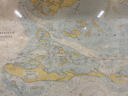
Sold2024Vintage Framed Pine Island & Lacoste Island MapVintage full color paper map, marked on top Pine island, Charlotte harbor and Lacosta island. Showing waterways and directions. Framed in a wooden frame. Approx 14 x 18 inches window measures 11.5 x 1See Sold Price
Sold202417TH C. MERCATOR'S MAP - SMALLER ISLANDS ANGLESEA CHANNELL ISLANDS17TH CENTURY (1636) HAND COLORED MERCATOR'S MAP OF THE SMALLER ISLANDS, ANGLESEY CHANNELL ISLANDS, ISLE OF WIGHT, JARSAY, GARNESAY - FRAME MEASURES APPROX. 21" X 17"See Sold Price
Sold20221970s Nautical Navigations Maps Long Island Sound, Block Island & More 47"x35"1970s Nautical Navigations Maps Long Island Sound, Block Island & More 47"x35"See Sold Price
Sold2021Boating maps, royal island harbor, egg islands, currentMaps from 1981 tropic Isle publishers, Inc By Harry Kline, Royal island harbor, egg Islands, current island Anchorage. Size 11“ x 17“See Sold Price
Sold20171851 Tallis Map of Islands in the Atlantic1851 Tallis Map of Islands in the Atlantic J. Tallis 1851 London 14 x 10 in. plus matting Beautiful steel engraved map consisting of four maps of the islands: the island groups of Cape Verde, CanariesSee Sold Price
Sold2017Baldwin / Kitchin: Antique Maps Windward Islands, 1782Title/Content of Map: 1782 Baldwin / Kitchin Maps of the Windward Islands -- Island of St. Lucia [on sheet with] Island of St. Vincent [on sheet with] Island of Barbados [on sheet with] Chart of PartSee Sold Price
Sold20231902 Cram Map of Long Island -- Map of Long Island New YorkTitle: 1902 Cram Map of Long Island -- Map of Long Island New York Cartographer: G Cram Year/Place: 1902, Chicago Dimensions: 9.8 X 12.4 in. Description: This is an attractive map of Long island withSee Sold Price
Sold2022Submarine Map of Long Island Sound, Block IslandSubmarine Map of Long Island Sound, Block Island, together with a book on United States Submarines by Robert Hatfield Barnes with had inscribed dedication to the Officers and the Men of the United StaSee Sold Price
Sold2019Vintage Map of Fiji Islands and Samoa IslandsVintage Map of Fiji Islands and Samoa IslandsSee Sold Price
Sold2021Redstone Studios Oil on Canvas, "Map of NantucketRedstone Studios Oil on Canvas, "Map of Nantucket Island", including Muskeget Island, Tuckernuck Island and various points of interest including Brant Point Lighthouse, Sankaty Lighthouse, Great PointSee Sold Price
Sold2022Chinese Jade Seal w/ BoxIncluding a jade seal of rectangular form surmounted with a hollow dragon-turtle, the celadon stone with russet inclusions, a tin type photo, and a cloth map of Mindoro Island and Samar Island, with aSee Sold Price
Sold2024Claus Hoie (1911-2007) Long Island WatercolorClaus Hoie (1911-2007) Norwegian, Long Island NY themed watercolor. Dated 1998. A watercolor of Local Landmarks within a map of Long Island, map of Long Island & local landmarks. Including Montauk LigSee Sold Price
Sold2021Map Of Rhode Island, 1849Road Map of the Island of Rhode Island or Aquidneck, circa 1849, by Charles E. Hammett. 17 x 11 3/4 inches. Margin tears and imperfections with some toning along the edges.See Sold Price
Sold2023LEROY NEIMAN AMERICAS CHALLENGE SAILBOATS PRINTLEROY NEIMAN AMERICAS CHALLENGE SAILBOATS PRINT ON MARTHAS VINEYARD BLOCK ISLAND NEWPORT RHODE ISLAND MAP -SIGNED IN PLATE DATED 1964- 35" x 30"APPROX TO FRAME-PRE OWNED CONDITION-DP2323See Sold Price
Sold2016Framed Map of Connecticut, Rhode Island, & LongWilliams & Co. Custom Wooden Frame. Topographic map of Connecticut, Rhode Island, Long Island. Dimensions: 14x2 in L X 13.5x2 in W. good conditionSee Sold Price
Sold2017Virgin Islands to Margarita Island, Venezuela Map, 1680Isles d'Amerique dites Caribes et Antilles et de Barlovento. A beautifully colored exemplar of Du Val's uncommon map of the Lesser Antilles from the Virgin Islands to Margarita Island off the coast ofSee Sold Price
2022A Rare Solomon Islands Fisher Wife SculptureAntique carved wooden female effigy of a "Fisher wife" holding a staff with frigate bird and bonita fish symbols. Santa Cataline Island, Solomon islands. Carved from Tobago wood with inlaid shell eyesSee Sold Price
Sold2021Van der Aa 1730 Map of Indonesia & Spice IslandsPublished by Van der Aa. Engraved map of the Spice Islands and the Island of the Celebes. Pictorial title cartouche features a native surrounded by baskets and bundles of spices. Conservation framed.See Sold Price
Jun 08Nadeau's Auction GalleryTen: Ernst Haas (Austrian 1921-1986) from "The Creation" Portfolio$1,000
7 hrs LeftRapid Estate Liquidators and Auction GalleryVintage Framed Cat Island Nautical Map Print$55
7 days LeftJasper52Partie Occidentale de l’Afrique. West Africa coast Canary islands BONNE 1788 map$15
267 Lots AwayForum AuctionsSt. Helena.- Beatson (Maj.-Gen. Alexander) Tracts Relative to the Island of St. Helena, 1816£400
1 day LeftFreeman's | Hindman[CIVIL WAR]. Archive of items related to Elisha Hunt RHODES (1842-1917), 2nd Rhode Island Volunteer$750
Jun 08Early American History Auctionsc 1730 Hand-Colored Colonial Era Map of the Americas, California shown as an Island, Matted + Framed$500(1 bid)


![Baldwin / Kitchin: Antique Maps Windward Islands, 1782: Title/Content of Map: 1782 Baldwin / Kitchin Maps of the Windward Islands -- Island of St. Lucia [on sheet with] Island of St. Vincent [on sheet with] Island of Barbados [on sheet with] Chart of Part](https://p1.liveauctioneers.com/5584/110608/56777137_1_x.jpg?height=310&quality=70&version=1507840413)


![[CIVIL WAR]. Archive of items related to Elisha Hunt RHODES (1842-1917), 2nd Rhode Island Volunteer (1 of 6)](https://p1.liveauctioneers.com/197/329785/177758366_1_x.jpg?height=282&quality=70&version=1715625218)
