Sold202317th c map of Venezuela, Hondius/BlaeuVenezuela. Hondius/Blaeu, Venezuela, cum Parte Australi Novae Andalusiae, from Novus Atlas, 1647. Dimensions:The sheet is 19" x 23". Provenance:From a Main Line collection.See Sold Price
Sold2016Venezuela, Arnoldus Montanus 1671Title: Venezuela cum parte Australi Novae Andalusiae Subject: Venezuela Maker: Arnoldus Montanus Date: 1671, Amsterdam Size: 11.4 x 14.25 inches From Montanus' "De Nieuwe en Onbekende Weereld: of BescSee Sold Price
Sold2017Hondius: Antique Map of Venezuela, 1630Map: Venezuela, Cum Parti Novae Andalusiae." Publication Date: 1630 ca. Authors: H. HONDIUS, HONDIUS, HENRICUS (1597-1651)/E. S. HAMERSVELDT/S. ROGERIUS Publisher: H. HONDIUS Size: Folio – 14.75 H xSee Sold Price
Sold2018Old map of Venezuela, Janssonius, Amstelodami, circaAntique map of Venezuela, Novae Andalusiae Janssonius, Amstelodami, circa 1650, map shows Venezuela with the Caribbean and Windward Islands, Aruba, Curacao, Bonaire, Los Roques, Isla la Orchila, IslaSee Sold Price
Sold20231671 Ogilby Map of Panama and Northern South America -- Terra Firma et Novum Regnum Granatense etDescriptionTitle: 1671 Ogilby Map of Panama and Northern South America -- Terra Firma et Novum Regnum Granatense et PopayanCartographer: J OgilbyYear / Place: 1671, LondonMap Dimension (in.): 11.3 X 1See Sold Price
Sold2017Nova Mexico folding map from American 1671 by OgilbyOgilby, John, 1600-1676, Montanus, Arnoldus, 1625?-1683, Nova Mexico from Novissima et Accuratissima Totius Americae Descriptio.11 x 21.25 inches, America: Being The Latest, And Most accurate DescriptSee Sold Price
Sold2024John Ogilby 1671 Antique "Nova Virginiae Tabula" Pencil Signed Hand Colored Virginia MapAntique 1671 hand-colored and pencil-signed "Nova Virginiae Tabula" map of Virginia and Chesapeake region. In good overall condition, with age-appropriate wear. Approx. image size 11 1/4" x 14". ApproSee Sold Price
Sold2018Montanus / Ogilby Novi BelgiMontanus, Petrus (1595-1638) & Ogilby, John (1600-1676). Nova Belgii Quod Nunc Novi Jork Vocatur... Engraved map with original color. J. Ogilby, 1671. 11 ½" x 14 ½" sheet. Centering on Long IslaSee Sold Price
Sold2023Ogilby / Montanus Map of the AmericasOGILBY, John (1600-1676) / MONTANUS, Arnoldus (c. 1625–1683). Insulae Americanae in Oceano Septentrionali cum Terris adiacentibus. Engraved map. London, 1671 (Second state). 16" x 20 1/2" sheet, 33"See Sold Price
Sold2020Map, John OgilbyJohn Ogilby (British, 1600-1676), "Nova Hispania Nova Galicia Guatimala (with part of Florida and Cuba)," 1671, hand-colored engraving, sight (image): 14"h x 11.5"w, overall (with mat/unframed): 17.5"See Sold Price
Sold2022Nova Hispania Nova Galicia Guatimala. 1671.[Map/South America] Ogilby, John; Montanus Arnoldus. Nova Hispania Nova Galicia Guatimala. 1671. Hand colored copperplate engraved map. Framed: This map, based on the cartography of Hessel Gerritsz, iSee Sold Price
Sold2017WILLEM JANSZOON BLAEU 1640 MAP OF COLUMBIA ETC."Terra Firma et Novum Regnum Granatense et Popayan" Fine old color example of Blaeu's map of Colombia, part of Ecuador extending south to Esmereldas, and Venezuela extending east nearly to Caracas. InSee Sold Price
Sold2018Jansson: Terra Firma / Colombia, Venezuela, PanamaTerra Firma et Novum Regnum Granatense et Popayan. Jansson's nearly identical version of Blaeu's Terra Firma map. Jansson's typography and engraving are somewhat less refined than Blaeu's, but his milSee Sold Price
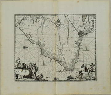
Sold20231671 Ogilby Map of Brazil -- BrasiliaTitle: 1671 Ogilby Map of Brazil -- Brasilia Cartographer: J Ogilby Year / Place: 1671, London Map Dimension (in.): 11.3 X 13.8 in. This is an excellent map of the eastern part of Brazil. There is anSee Sold Price
Sold20201671 Montanus/Ogilby Map of Chile -- ChiliTitle/Content of Map: 1671 Montanus/Ogilby Map of Chile -- Chili Cartographer: Montanus/Ogilby Year/Place: 1671, London Size: 11.2 X 14.2 in. This is a very attractive map covering the coastal regionSee Sold Price
Sold2017ANTIQUE MAP OF ISLE OF JAVA, JAN JANNSON 17TH CFramed engraved and colored map, " Insulae Iavae cum Parte Insularum Borneo Sumatrae, et circumjacentium insularum novissima delineatio", map of Isle of Java, possibly mid-late 17th c., by Jan JanssonSee Sold Price
Sold20201671 Montanus Map of Very Early Virginia -- NovaTitle/Content of Map: 1671 Montanus Map of Very Early Virginia -- Nova Virginiae Tabula Cartographer: A. Montanus / J. Ogilby Year/Place: 1671 c Size: 14.1 x 11.5 in. This is an outstanding decorativeSee Sold Price
Sold202117th C. Dutch Map of Southern Spain by F. de Wit**Originally Listed At $300** Fredericum de Wit (Dutch, 1630-1706)."Regnorum Castellae Novae, Andalusiae, Granadae Valentiae, et Murciae" copper engraving with hand coloring issued in Amsterdam, lateSee Sold Price
Sold2017Montanus / Ogilby: Antique Map of Central America, 1671Map: Yucatan . . . et Guatimala Cartographer: Montanus / Ogilby Place & Date: Amsterdam / 1671 Size: 14 1/4" x 11 1/4" Condition: b&w; overall age toning and some spotting The detailed map of southeasSee Sold Price
Sold2019Montanus / Ogilby: Antique Map of Central America, 1671The detailed map of southeastern Mexico and Central America from Ogilby's English edition of Montanus' influential history of America. The map encompasses the Mexican heartland, the Yucatan peninsula,See Sold Price
Sold2021Montanus 1671 Map of Mexico & Central AmericaDESCRIPTION: Map by cartographer Montanus extending to Costa Rica, based off cartographer Gerritsz's work. Title cartouche is bright and colorful reading "NOVA HISPANIA NOVA GALICIA GUATIMALA" and depSee Sold Price
Sold2016ANTIQUE GOLD CHARM BRACELET 12 CHARMS, 31.2 GRAMS 8K,THIS IS AN ANTIQUE BRACELET WITH 12 CHARMS THAT WERE PROBABLY COLLECTED DURING VARIOUS TRAVELS. MOST OF THE CHARMS ARE MARKED AND TESTED 14K. THE "VENEZUELA" MAP CHARM IS 18K. ONLY THE CLOCK AND THE BSee Sold Price
Sold2016Seutter map of Southeast AsiaHeading: Author: Seutter, Matthew Title: India Orientalis cum Adjacentibus Insulis Nova Delineatione ob oculos posita Place Published: Augsburg Publisher: Date Published: [c.1745] DescSee Sold Price
Sold2024Weigel map of Americas Calif. an islandHeading: (America) Author: Weigel, Christopher Title: Novi Orbis sive Totius Americae cum Adiacentibus Insulis Nova Exhibitio Place Published: Nuremberg Publisher: Date Published: [1725] <See Sold Price
2 days LeftJasper521671 Ogilby Map of Venezuela -- Venezuela, cum Parte Australi Novae Andalusiae$160
3 days LeftJasper52S AMERICA NW. Venezuela, New Granada(Colombia) w/Panama Ecuador.BLACKIE 1882 map$10
3 days LeftJasper52Cartagène, Ste. Marthe et Venezuela'. Colombia. Cartagena. BELLIN 1754 map$80
3 days LeftJasper52NW SOUTH AMERICA. Colombia Venezuela Ecuador Peru Bolivia Brazil. Lima 1907 map$10
3 days LeftJasper52Carte du Nouveau Royaume de Grenade… Colombia Venezuela Guyana. BONNE 1780 map$35
3 days LeftJasper52South America #1. Peru Ecuador Colombia Venezuela Amazonia. BARTHOLOMEW 1893 map$8
Featured3 days LeftJasper52Carte de Colombie et des Guyanes. Colombia Venezuela Guianas. LAPIE 1828 map$100
3 days LeftJasper52South America, North. Amazonia Brazil Venezuela Colombia Ecuador TIMES 1900 map$40
3 days LeftJasper52Amér. Mér. Colombie #2. Western Venezuela & NE Colombia. VANDERMAELEN 1827 map$100
3 days LeftJasper52SOUTH AMERICA (NORTH).Colombia Venezuela Ecuador British Guiana Panama 1920 map$10
Featured3 days LeftJasper52South America. New Granada & Venezuela. Colombia Panama. SWANSTON 1860 old map$50
Featured3 days LeftJasper52Johnson's Venezuela, New Granada, Ecuador, Peru, Bolivia, Chile, Guiana 1861 map$85


![Nova Hispania Nova Galicia Guatimala. 1671.: [Map/South America] Ogilby, John; Montanus Arnoldus. Nova Hispania Nova Galicia Guatimala. 1671. Hand colored copperplate engraved map. Framed: This map, based on the cartography of Hessel Gerritsz, i](https://p1.liveauctioneers.com/179/268856/140616119_1_x.jpg?height=310&quality=70&version=1668545725)


![Seutter map of Southeast Asia: Heading: Author: Seutter, Matthew Title: India Orientalis cum Adjacentibus Insulis Nova Delineatione ob oculos posita Place Published: Augsburg Publisher: Date Published: [c.1745] Desc](https://p1.liveauctioneers.com/642/86438/44449722_1_x.jpg?height=310&quality=70&version=1458591928)
![Weigel map of Americas Calif. an island: Heading: (America) Author: Weigel, Christopher Title: Novi Orbis sive Totius Americae cum Adiacentibus Insulis Nova Exhibitio Place Published: Nuremberg Publisher: Date Published: [1725] <](https://p1.liveauctioneers.com/642/319971/171838511_1_x.jpg?height=310&quality=70&version=1708735483)


